Meteorologists warn of El Niño by end of the year
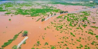
An aerial photo of flooded roads along the Garissa-Mombasa road in Tana River County taken earlier during the el-nino floods in October 2023.
What you need to know:
- During El Niño, Pacific waters heat up, triggering heavy winters, devastating droughts, and wildfires.
- La Niña, which brings strong winds and cooler ocean temperatures that can trigger hurricanes over the Atlantic, balances out El Niño.
- On average, every two to seven years, a warm El Niño followed by a cold La Niña is triggered by the ENSO cycle.
El Niño could strike towards the end of this year, causing temperatures to soar globally, meteorologists have warned.
According to the newly released State of the Climate in Kenya 2025 report by the Kenya Meteorological Department (KMD), there is a projected likelihood of an El Niño event occurring towards the end of 2026.
“Multi-model ensembles indicate a 58–61 per cent probability of El Niño conditions dominating from June to December,” the report read.

Although the La Niña phase is currently underway, scientists forecast a 62 per cent probability of a switch taking place between June and December. Should the prediction hold, it will be the third time the weather phenomenon has occurred in the last 30 years.
Also read: Why coming rains will be so extreme
El Niño and La Niña, jointly known as the El Niño–Southern Oscillation (ENSO), refer to the warm and cool phases of a natural climate pattern across the Pacific Ocean that plays a critical role in shaping global climate. Every two to seven years, the Earth shifts irregularly between the two, triggering changes in ocean temperatures and disrupting rainfall and wind patterns.
During El Niño, Pacific waters heat up, triggering heavy winters, devastating droughts, and wildfires. La Niña, which brings strong winds and cooler ocean temperatures that can trigger hurricanes over the Atlantic, balances out El Niño. On average, every two to seven years, a warm El Niño followed by a cold La Niña is triggered by the ENSO cycle.
According to American climatologist Zeke Hausfather, during an intense El Niño event, global temperatures temporarily rise by up to 0.2°C, with the maximum global mean temperature occurring about three to four months after El Niño peaks in the Pacific. “In the past week, a number of modelling groups that try to forecast future ENSO conditions have released forecasts that suggest that a very strong El Niño may be in the works for late 2026,” Hausfather stated.
The scientist scrutinised 11 different models updated since the beginning of March, yielding a total of 433 ENSO predictions, according to his blog, Climate Brink, published this month. “These clearly show that a strong El Niño is indeed likely to develop later in the year,” Hausfather stated.
The latest forecast is an improvement from earlier predictions made in January and February, which indicated a less intense El Niño. According to experts, the last ordinary
El Niño occurred between 2023 and 2024, lasting 10 months, with ocean water temperatures rising 0.5°C above the long-term average. A super El Niño, on the other hand, occurs when sea surface temperatures reach at least 2°C above normal.
The latest estimates indicate mean temperatures of about 2.5°C, significantly higher than the 2023/2024 El Niño, but nearly matching the super El Niño experienced a decade ago in 2015/2016. That event, scientists say, was among the strongest on record.
“So, what does this mean for global temperatures this year and in 2027? All things being equal, the lag between peak El Niño conditions and the global surface temperature response would result in the largest impacts on 2027 temperatures,” Zeke explained.
Typically, El Niño peaks between November and January, meaning the event will still boost 2026 temperatures, though it may be insufficient to set a new record this year, scientists explain. If the super El Niño forecast occurs, experts say it is highly likely that 2027 will set a new temperature record by a significant margin.
2024 was the hottest year on record, coinciding with an El Niño event that saw average global temperatures exceed 1.5°C above pre-industrial levels for the first time.
In Kenya, the El Niño event between October 2023 and May 2024 resulted in two consecutive seasons of extreme rainfall and flooding across 46 of the 47 counties.
However, a recent study warned that El Niño could become a regular occurrence every two to five years by mid-century. The aftermath would be years of drought and flooding back to back in a phenomenon known as whiplash.
During whiplash, seasons of intense heat and drought alternate with heavy rains and floods. The ground is scorched, vegetation is killed or burnt by wildfires, increasing flood risk and reducing the region’s ability to absorb water. In the years that follow, extreme flooding damages reservoirs and waterways, making it harder to conserve water for the next drought season.