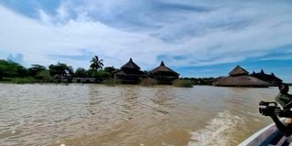
Some of the structures at Soi Safari Lodge on the shores of Lake Baringo have been submerged due to the rising water level of the lake.


In six months, Mary Esekon, a mother of eight, has been displaced five times from Imprezza village due to the swelling of Lake Turkana that has submerged homes, shops, and two schools at Kalokol Location in Turkana Central Sub County.
Her children, who learn at nearby Natole primary, are out of school as classes, administration block and store have all been submerged.
"We are facing a dire humanitarian crisis because I lost all my belongings, food, and source of livelihood. I don't have nets for my children in an area currently recording high malaria cases," Ms Esekon told Nation.Africa on Sunday.
Area Chief Stephen Jamada confirmed that at least 3,000 families in his area had been hit hard by the sustained swelling of the lake.
"Ten villages including Impreza, Daraja, Natirae, and Natole are the most affected. Most of the fishermen who came from Lodwar, Kisumu, and Loima decades ago have been forced to go back to their ancestral homes where they used to practice pastoralism. The remaining families are appealing for relocation to higher grounds, food, clothing, and medical attention," Mr Jamada said.
The water levels in the Rift Valley lakes have risen drastically in recent years, submerging adjacent structures including people’s homes, social amenities including schools, hospitals, and even tourist hotels.
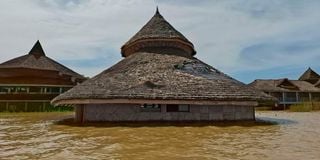
Some of the structures at Soi Safari Lodge on the shores of Lake Baringo that have been submerged due to the rising water level of the lake.
Lakes that have increased over time include Baringo, Bogoria, Turkana, and Nakuru, causing massive displacement of people living adjacent to them.
Siltation
According to environmentalist Raphael Kimosop, a Baringo County catchment and wetlands protection officer, apart from siltation upstream caused by human activities, the rise in water levels in the North Rift lakes is also caused by the movement of tectonic plates.
This means lakes Baringo and Bogoria, which are in the lowest bed of the Rift Valley, are more susceptible to fault lines— thus leading the water aquifer to crack due to saturation.
“In this case, the water is percolating from the aquifers to the lakes, leading to its levels to rise. The rise is also caused by the heavy rains which have been above normal for some time, thus much of the water is drained to the lake courtesy of the water from the catchment areas,” he said.
The heavy rains and siltation caused by human activities upstream are, however, major contributors, with the environmentalists saying that people are not practising sustainable land management, thus leading to the soils being swept downstream to the lakes.
“The rising water levels in the Rift Valley Lakes which began in 2011 are linked to the heavy rains. It has also risen to above normal especially Lakes Baringo and Bogoria, which is majorly aggravated by siltation. Many farmers in Baringo are not practising sustainable land management causing siltation in the Lakes,” said Mr Kimosop.
Lake Baringo senior warden Jackson Komen said the water had increased by an average of 15 meters around the lake in three months, and could continue to rise should the rains persist.
He attributed the rise to long rains and siltation caused by human activities upstream.
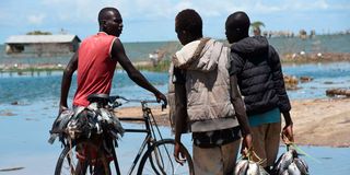
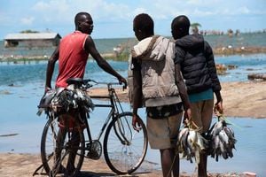
Fishermen with their catch at Kalokol area of Lake Turkana in Turkana County on September 19, 2021.
“We fear that should the rains persist, it will swallow more structures including roads and other social amenities. We urge locals living adjacent to the lake to move to safer areas to avert more disasters because, by the look of things, the water levels will even increase beyond the size it reached after it flooded four years ago,” said the warden.
He raised fairs of human-wildlife conflicts in villages adjacent to the hippos and crocodile-infested water bodies.
Prof Simon Onywere, a spatial environmental planner, geologist, and associate Professor at Kenyatta University said owing to the long rains that began in August, the lakes tend to rise gradually and recede when the rains stop.
“When it rains, the water levels rise enormously and the decrease is regular when it stops due to evapotranspiration because the water exit is at a constant,” explained Prof Onywere.
“The lakes burst their banks because there is a runoff upstream and the land cannot hold water because it is degraded. In essence, the land is supposed to hold water so that it can infiltrate the ground and leave slowly as it feeds the Rivers at a constant flow.”
Flooding
For instance, the watershed in Cherangany that serves the Turkwel Gorge is degraded and whenever it rains, there is a lot of runoff that leads to the tremendous rise of water levels in the Gorge, he said.
“When there is heavy rainfall, the water from the rivers that feed them flows to the lakes. The water that goes into the lakes carries silt, which leads the water basin to be shallow due to the siltation, causing the water to move wider thus flooding. For instance, there is no day when Lake Baringo does not receive silted water because according to the satellite images, the lake water has never been clear,” said the University don.

A main gate leading to Lake Bogoria National Reserve, which was submerged after the lake burst its banks
He further explained that the watershed in Tugen Hills drains into Lake Bogoria, which takes with it a lot of silt because it is eroded due to human activities.
“Lake Nakuru itself is a nightmare because the flooding occupied a big chunk of the park, submerging the habitat of the wildlife,” said Prof Onywere.
In Turkana County, Ms Esekon was among 3,000 families at Kalokol who benefited from humanitarian support from the International Emergency Service team of the Salvation Army Church on Saturday.
Mr Benjamin Omuga, Emergency Service Officer from Salvation Army, Kenya West Territory said that the situation was worsening and victims were in dire need of relief food.
"Turkana is prone to drought and sometimes due to climate change is prone to unusual but destructive floods like what we are experiencing with Lake Turkana. A large number of communities have been displaced and as a church we have reached out to 3,000 families with food that will last for two weeks, drugs, dignity kits, and blankets," Mr Omuga said.
He called on other humanitarian agencies to support people displaced by the disaster as more villages are yet to be reached.
Salvation Army Kenya West Territory Development Secretary Major Hudson Muhalia called on the government to relocate the affected families as the anticipated rainfalls in October, November, and December might worsen the situation.
"The swelling of the lake has interrupted learning in schools that were generally banking on school feeding programmes to boost enrollment. We have also donated food to two schools where children are now learning under trees," Mr Muhalia said.
In Baringo County, Lake Bogoria senior warden James Kimaru said the heavy rains have caused it to burst its banks, rising from its initial 34 km square two months ago to 40 km square.
In March 2020, water levels at Lakes Baringo and Bogoria increased tremendously, swallowing adjacent structures including hotels, business premises, and other social amenities.
More than 10,000 people bordering the lake were left homeless after their houses were swallowed by the drastic rise in water levels.
Lake Baringo increased from 236 km square in 2015 to approximately 278 km square, posing a threat to adjacent structures including homesteads and institutions, while Lake Bogoria from 34 km square to approximately 45 km square in one month.
Big blow
The tourism sector was dealt a big blow by the rising water levels with property worth billions being lost after five major hotels were submerged by raging floods in Baringo County.
Soi Safari Lodge, Roberts Camp, Lake Breeze, and block hotel at the shores of Lake Baringo are staring at heavy losses after the lake burst its banks swallowing a section of the facilities.
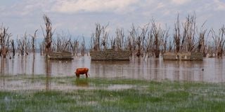
A cow grazes on the shores of Lake Nakuru on 26 May 26, 2024. The lake's waters have risen, displacing dozens of residents of Mwariki village in Nakuru County.
A report by the Kenyan Government and the United Nations Development Programme (UNDP) that studied rising water levels in the Rift Valley lakes in 2020 attributed the phenomenon to climate change, siltation caused by human activities, and geologic and tectonic activities.
Climate change was reported as the main reason for the rising water levels, with changes in land use practices being found to have led to increased runoff, causing larger volumes of water to flow directly and rapidly from the land surface into the lakes.
Findings of the research carried out from 2010 to 2020 established that Lake Turkana increased by 10 percent from 7,485km square to 8, 265kms square, while Lake Baringo increased exponentially from 128 km square to 268 km, a rise of more than 108 percent.
Lake Bogoria on the other hand also rose by more than 25 percent, from 34 km to 43kms square while Nakuru also rose from 40kms to 68kms, an increase of 70 percent respectively.
The increased inflow of fresh water into some of these lakes has created instability in the already fragile ecology of the lakes, negatively affecting the resilience and distribution of certain water species.
According to the report, Lake Baringo was one of the worst affected lakes in the Rift Valley flooding, with an estimated area of 108.57 km2. The flooding displaced several settlements bordering the lake, particularly the Southern and the Western parts, and caused major disturbances including destruction and loss of property, and animal and human lives.
Because of the phenomenon, many families have been relocating their homes to higher grounds every few months as the lake rises. Some households have rebuilt their homes up to 5 times since the flooding began.