Why conservationists are opposing Aberdare Forest road

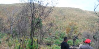
A view of Aberdare National Park in Nyeri County on March 2 .
What you need to know:
- At 4,000 metres above sea level, the Aberdare Ranges are a 100-kilometre hilly expanse of forests.
- Here, streams of water gush out of the ground, crystal clear, cold to the touch leaving a tingly and frozen feeling to your hands.
When you drive into the Aberdare National Park from the Muiga gate in Nyeri County, the cold breeze welcomes you to a picturesque view of hills towering above a forested canopy covered in moss and overgrowth. This is a vivid throttle back into the past and you will not help but be filled with gratitude for being present to witness ancient trees, whose canopy in-part allows for some glimmer of light to pass through. Its breathtaking beauty, chilling, in every sense as goosebumps prompt you to tug your jacket closer to your body for some warmth.
At 4,000 metres above sea level, the Aberdare Ranges are a 100-kilometre hilly expanse of forests. The indigenous forests giving way to bamboo and finally the moorland vegetation up in the hills where clouds kiss the tips of the hills before pouring down as rain. These ranges stretch over three counties, Nyeri, Laikipia and Nyandarua. Here, streams of water gush out of the ground, crystal clear, cold to the touch leaving a tingly and frozen feeling to your hands.
This is one of the five water towers in the country. From here are rivers that support millions of livelihoods in North Eastern Kenya, Central and South Rift Valley.
It took more than two decades to erect a 400km-perimeter wall along the Aberdare National Park to protect the ecosystem from human induced degradation and while a fence may have sheltered the Aberdare ranges from physical interference, it has not been immune to the vagaries of the dry spell.
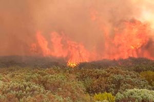
We visited the Aberdare National Park in March at the height of the worst drought in 40 years and the park had just suffered its worst forest fire where more than 40,000 acres of the moorland was destroyed.
Climate change not withstanding, a government proposal to proceed with the upgrading of the Ihite- Aberdare Forest- Ndunyu Njeru Road has been met with resistance from conservationists who say the 25-kilometres of the 54-kilometre stretch will pass through the Aberdare Forest, destroying critical vegetation and affecting wildlife populations like the elephants and the Mountain Bongo, whose highest population in Kenya is found within the Aberdare.
The East African Wildlife Society (EAWLS) is calling for the National Environment Management Authority to reject the Environment Impact Assessment (EAI) that gives the project a go-ahead, saying it is misleading, inaccurate, biased and lacks merit.
“The EAI report fails to recognise the loss of revenue by Kenya Wildlife Service (KWS) and Kenya Forest Service (KFS) from enabling free access to parks and forest reserves, nor does it incorporate strategies for addressing increased surveillance costs in protected areas,” reads a statement by EAWLS.
This is not the first time the upgrading of this road has been met with resistance. A similar proposal was shelved six years ago after conservation groups prevailed over the then Minister for Environment Keriako Tobiko to oppose its development. One of these groups is the Kenya National Water Resource Users Association (KNWRUA), which says the road will disrupt the flow of seven streams that feed into rivers that pour into Lake Naivasha.
“In the immediate term, should water levels in rivers Mukunga, Turasha and Kiriti decline, that means Lake Naivasha’s water levels will decrease and that will have ripple effect even to the national economy,” says Mr Enoch Kiminta, the executive officer of KNWRUA. “Though the EIA says only 440 hectares of the forest will be affected, my projection is that about 1,000 hectares will be affected since the road will cut through the bamboo, indigenous trees and the Moorland, where an endangered birds populate,” adds Mr Kiminta
The birds that Mr Kiminta is talking about are the Aberdare cisticola and Sharpe’s long claw, which are domiciled in the Aberdare Ranges and Kinangop Plateau. The numbers of these birds have been drastically falling due to habitat loss.
“It’s worrying because the birds have been disappearing due to farming and developments like road construction. The birds usually do not find a conducive place to resettle,” Lucy Ngare, an official at Friends of Kinangop Plateau, a community-based organisation that champions for environmental conservation, says.
President William Ruto and his deputy Rigathi Gachagua have charged Members of Parliament and senators from Nyeri and Nyandarua counties to gather public support for the Sh8.8 billion project.
Nyandarua Senator John Methu, who is also the chair of the Committee on Water Lands Environment and Natural Resources, has defended road, saying it is but a continuation of the initial works done by the government in 1986 and not a new road project.
The construction of the road is yet to start, with the National Environment Management Authority having concluded another round of public participation to find out if the Ihite- Aberdare- Ndunyu Njeru Road will go on or not.


