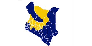
The colour-coded map from last night showing the counties where the Azimio Blue and Kenya Kwanza Yellow were leading in the vote count showed an interesting pattern.
The yellow of Deputy President William Ruto ’s was solid in a tight and populous sector across the middle of the country, comprising his Rift Valley bastions stretching north across Upper Eastern counties of Isiolo and Marsabit to the Ethiopia border, west to the Uganda border; and taking in President Uhuru Kenyatta ’s Mt Kenya region.
The densely populated yellow counties would by area have occupied more than half the country, but for an interesting blue projection from the Sudan border to the northwest, Turkana and Samburu counties in a south-easterly direction right into the Ruto heartland.
The blue dagger was complemented by swathe of blue in Mr Raila Odinga ’s Nyanza strongholds, running south through the lower reaches of the Rift Valley, then east to link with the expansive Lower Eastern region and further into the coastal region, and from hence upwards through the north-eastern region adjacent to the Somalia border.
The Raila blue expanse represents a pincer movement or complete encirclement of the Ruto yellow, and territorial dominance.
Appearances, however, can be deceiving. The blue expanse across the Coast, North Eastern and Upper Rift Valley may make up a vast amount of territory, but it is sparsely populated, while the much smaller yellow where Dr Ruto is dominant is densely packed with humanity. It is people who vote, not land area.
All the same, results trickling in last night indicated that while Dr Ruto and Mr Odinga remained locked in a tight race, earlier projections from the pre-election opinion polls had been thrown helter-skelter by a historically low voter turnout.
As projected, Dr Ruto retained his Rift Valley base, scooping over 90 of the vote in most counties, while Mr Odinga did the same in his Nyanza bedrock.
The DP also ate handsomely into Coast and Western Kenya regions previously dominated by his Azimio rival.
A key determinant, however, might turn out to be in the number of voters who stayed away. With a national figure of just around 65 per cent, Mr Odinga reaped well with his Nyanza base, recording the highest turnout in the country at 80 per cent, while Dr Ruto’s Rift Valley barely skimmed 70 per cent.
Then there is the populous Mr Kenya region, which gave the Jubilee Party pair of President Kenyatta and Dr Ruto something in the region of 90 per cent of its vote in the last two elections while recording extremely high turnouts.
With the outgoing President spurning his deputy of two terms and backing the fifth bid of the veteran opposition chief, the Odinga camp expected a big boost, up to 30 per cent or more, of a vote that defied Mr Kenyatta and threw its lot with Ruto.
The 2013 and 2017 campaigns had seen massive mobilisation in Mount Kenya, first to ‘rescue’ a favourite son from the jaws of the International Criminal Court, and the second time to ensure the hated ‘kimundu’ —as Mr Kenyatta’s vernacular radio presenters derogatively referred to Mr Odinga—did not take away their birthright.
It turned out that not even President Kenyatta’s intervention could earn affection for Mr Odinga, especially when he, too, has been roundly rejected.
Mr Odinga struggled to get 20 per cent of the Mt Kenya vote, which might have been fatal but for the fact that with no serious candidate of their own to rally around, the droves stayed away.
A low 55 per cent voter turnout hurt Mr Ruto badly in the Mountain, even though he dominated the presidential vote and scooped nearly all the legislative seats.
Meanwhile, as results continued streaming in last night, attention shifted to the slow pace, despite the fact that the Independent Electoral and Boundaries Commission had uploaded more than 80 per cent of result forms from over 46,000 polling stations.
By yesterday morning, none of the main media houses had managed to give a count of more than 1.5 million votes—shared roughly equally between the two main candidates—from a figure of around 14 million, yet the IEBC had already shared nearly all the counts from individual polling stations on its public portal.
By 8 pm last night, the Nation election portal was leading the count, with nearly seven million votes accounted for from some 22,000 of the 46,000 polling station result forms, Form 34 A.
That was still well short of the total votes cast or anything required to make a clear projection of the likely winner.
Public frustration at the slow pace was compounded by the fact that the three main media houses with the latest results on their TV stations and websites were projecting different tallies, adding to the confusion.
The reality is that the media had been thrust into unfamiliar territory by the decision of the electoral commission to perform the equivalent of a document dump.
Instead of doing its own tallies and giving regular updates from the National Tallying Centre at the Bomas of Kenya, the IEBC simply uploaded copies of the raw forms on the public portal; and left them for the media, political parties and any other interested groups to download them, key in the data and do their own tabulations.
That is a mammoth undertaking by any standards as the results from the counting centres were uploaded as scanned copies of the original handwritten forms, rather than data that could be easily transferred to a worksheet.
To add to the confusion, agents and propagandists from the two main political formations, Dr Ruto’s Kenya Kwanza alliance and Mr Odinga’s Azimio la Umoja coalition, went into overdrive, each claiming victory on social media and displaying their own tallies.
By not releasing any tallies and just making the raw polling station result forms available, the IEBC handed the media the primary role of calling the results, the American style-scenario where there is never a Wafula Chebukati, or their equivalent of an electoral management body chair, to announce the winner.
The job is done by CNN, CNBC, Fox News, ABC and the other major media houses. It is only much later that the results are verified at the state level and then by the Senate.
For Kenya’s elections on Tuesday, all the main media houses set up their own tallying centres, which were to be fed by data collected by reporters and correspondents from the 290 constituency tallying centres.
The ideal strategy would have been to collect data directly from the source, but none had the manpower and resources to cover 46,229 polling stations.
Still, initial projections were that the vote counting would proceed fairly quickly once the polling stations closed at 6 pm on Wednesday, allowing for the completed forms 34s to be transmitted to the constituency tallying centres, from where the totals from the polling stations in each constituency would generate a tally form known as 34B.
By last night, only a handful of the constituency tallies were available despite the fact that nearly all the polling station counts had been transmitted to the tallying centres.
That heralded another long wait as Mr Chebukati continued to stand firm against announcing any provisional results.