Report reveals irony of Kenya’s lakeside counties with almost no forests
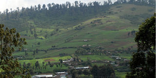
This 2012 photo shows human settlements at the foot of Logoman Forest, which is one of the Mau Forest Eastern Blocks. Siaya, Kisumu, Homa Bay, Migori and Kisii counties, which are around Lake Victoria, the world’s second largest fresh water lake, are ranked among the poorest in forest cover in Kenya. PHOTO | SULEIMAN MBATIAH | NATION
Kenya has an estimated forest cover of 6.9 per cent, more than five years after her 10 per cent target forest cover deadline lapsed.
Nyeri County is the most forested county, with 38.03 per cent of its land covered. Elgeyo-Marakwet County comes in second 37.49 per cent forest cover.
Ironically, Marsabit, Isiolo, Mandera, Turkana and Kitui counties, which are classified as arid or semi-arid areas, had better forest cover than the lakeside counties.
The report, which also ranked counties on the loss of forest cover between 1990 and 2010, places Elgeyo-Marakwet as the most deforested county, having lost 46.31 per cent of its forest cover.
Counties in average climatic conditions and water availability are dragging Kenya further from attaining the internationally recommended 10 per cent forest cover.
Siaya, Kisumu, Homa Bay, Migori and Kisii counties, which are around Lake Victoria, the world’s second largest fresh water lake, are ranked among the poorest in forest cover in Kenya.