The science that could help Nairobi manage its hidden water reserves
Sponsored by Regional Centre on Groundwater Resources Education, Training and Research
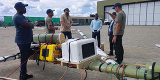
The SkyTEM and RCGW technical teams conduct a pre-flight systems check at Oryl Airpack, Kajiado County, ahead of the inaugural survey flight in March 2025.
By Pauline Kairu
A Kenyan-Danish project is using airborne technology to map underground formations beneath Nairobi and Kajiado, with the findings expected to guide groundwater management, borehole drilling and the replenishing of aquifers.
Nairobi’s water future may depend on something most residents never see: The geology beneath the city, the underground pathways through which water moves, and the areas where it can be stored and replenished.
As the capital expands and demand for water rises, groundwater has become an increasingly important part of the supply equation. Yet making reliable decisions about where to drill, how much water an aquifer can sustain and how best to protect it requires detailed knowledge of what lies underground.
A new mapping initiative is seeking to close that information gap, using helicopter-mounted electromagnetic technology to investigate the Nairobi Aquifer System and surrounding areas in Nairobi and Kajiado counties.
The Groundwater Mapping for Nairobi Aquifer System project, known as GROWANA, brings together Kenyan and Danish partners to develop detailed models of underground geological formations. The two-year initiative, running from October 2025 to October 2027, uses SkyTEM airborne electromagnetic technology to collect data that can help scientists understand the structure of the aquifer system.
The technology allows survey teams to investigate underground formations without having to drill at every location. Sensors mounted beneath a helicopter transmit electromagnetic signals and measure the responses from the ground, providing information about subsurface electrical properties that scientists can interpret alongside geological and groundwater data.
The survey is designed to investigate formations to depths of about 350 metres, providing a more detailed picture of the underground environment than would be possible from scattered borehole records alone.
Regional Centre on Groundwater Resources Ag CEO Geol Patrick Murunga says the technology could improve decisions about groundwater development. “The project will dramatically improve borehole siting accuracy, enable smart water infrastructure planning, and reduce the cost of failed drilling attempts.”
For households, businesses and water providers that depend on boreholes, better geological information can help narrow the search for suitable drilling sites, guide investigations before money is committed to drilling and support more informed decisions about future water infrastructure. But the importance of the project extends beyond finding places to drill.
Understanding the resource, not just locating it
Groundwater is often treated as a reserve that can be tapped whenever surface supplies fall short. In reality, Murunga explains, aquifers differ in their geology, how they receive water, how quickly they replenish and how much abstraction they can sustain.
A map of underground formations can improve understanding of these conditions, but it is not, by itself, a measurement of how much water is available or whether pumping is sustainable. That requires further hydrogeological assessment, groundwater-level monitoring, water-quality testing and estimates of recharge and abstraction.
The distinction matters for Nairobi where groundwater management must account for growing demand alongside the long-term health of the aquifer system.
RCGW’s own strategic plan identifies the Nairobi Aquifer System as a priority for sustainable groundwater management. The centre has also highlighted the need to protect groundwater from over-abstraction and pollution, which can undermine the reliability and suitability of supplies.
The GROWANA survey is expected to produce two and three-dimensional hydrogeological models that can help researchers interpret underground formations and guide subsequent investigations. The project’s planned final deliverables include a comprehensive model of the Nairobi Aquifer System by October 2027.
The findings are expected to support better decisions by regulators, planners, water utilities and researchers. Their value, however, will depend on how effectively the data are translated into groundwater management plans, drilling decisions and measures to protect the resource.
From mapping to replenishing aquifers
One of the project’s important objectives, according to Geol Murunga, is to identify potential sites for managed aquifer recharge, an approach that seeks to increase the amount of water entering underground storage. Rather than allowing all suitable rainfall or surface runoff to flow away, managed aquifer recharge directs water into the ground under carefully assessed conditions. Depending on the site, this may involve infiltration ponds, recharge wells or other engineered structures, he explains.
The approach requires detailed knowledge of local geology, the movement of groundwater, the quality of water used for recharge, and the environmental conditions of the proposed site. Poorly designed recharge can introduce contaminants or fail to replenish the intended aquifer.
RCGW has separately sought consultancy services for a managed aquifer recharge pilot in Nairobi. The work is intended to assess suitable sites and develop infrastructure and monitoring arrangements, linking the broader objective of groundwater sustainability to practical interventions on the ground.
The two strands of work address complementary questions. Mapping helps scientists understand the underground environment, while site-specific investigations establish whether water can be safely and effectively reintroduced into it.
Once suitable locations are identified and the necessary safeguards put in place, managed aquifer recharge could become one option for strengthening groundwater resilience. Its contribution would depend on the amount and quality of water available for recharge, the capacity of the aquifer and the arrangements for monitoring the results.
Building a stronger foundation for water security
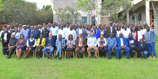
Stakeholders who attended the SkyTEM sensitisation and engagement workshop in Nairobi on March 12, 2026. They included geologists, hydrogeologists, academics, and other professionals.
The survey is a partnership involving the Regional Centre on Groundwater Resources Education, Training and Research, the Geological Survey of Denmark and Greenland, Aarhus University’s hydrogeophysics group, SkyTEM and Kenyan aviation company Level Up Aviation, with support from Danish development cooperation.
For SkyTEM field manager Paul Jardim, the airborne approach offers a way to investigate extensive areas without the need for drilling at every point.
“The exercise is completely safe and non-invasive. The system never flies over buildings. It maintains strict safety protocols,” says Jardim.
The survey covers the Nairobi-Kajiado aquifer system, including Nairobi, Ngong, Kiserian, Isinya and Kajiado town. Its results are intended to inform groundwater development and planning beyond individual borehole projects.
RCGW’s wider mandate includes groundwater research, aquifer mapping, training and the development of scientific information to guide decisions on groundwater management. The centre was established as a state corporation under the Ministry of Water, Sanitation and Irrigation.
The work also offers an opportunity to strengthen local expertise in groundwater science and improve access to information that can support public planning.
RCGW and its partners have indicated that the project’s findings will be shared with government agencies, water utilities, academic institutions and the public.
That access will be important. The benefits of better groundwater mapping will be greatest when the findings are used to guide decisions, inform investment and strengthen oversight of abstraction, rather than remaining technical products available only to specialists.
The project is not a substitute for investment in water supply infrastructure, nor can mapping alone guarantee that Nairobi will have enough groundwater to meet future demand. But it can help answer questions that are essential to making those investments wisely: Where groundwater occurs; how the aquifer is structured; which areas merit further investigation; and where replenishment may be feasible.
For a growing city increasingly reliant on complex water systems, knowing what lies underground is an important step towards managing the resource more deliberately. The test will be whether the new information leads to better decisions about where to drill, how much to abstract and how to protect the aquifer for the years ahead.