The National Disaster Operations Centre (NDOC) says it is planning for a worst-case scenario during the October-November-December short rains, with above-normal rainfall expected to disrupt several sectors, including transport, health and essential services. Meteorologists are forecasting strong El Niño conditions at a probability of 81 per cent, raising the risk of intense and prolonged rainfall across parts of the country.
NDOC estimates that about 1.5 million people could be affected by the rains, with about 500,000 potentially displaced.
Across the country, authorities are bracing for disruptions to critical infrastructure, with water supplies, electricity networks and communication systems among the key areas considered vulnerable to the expected rains.
The heightened risk is particularly acute in North Eastern Kenya, where authorities warn that major roads could become impassable for months, severely disrupting road transport and movement of people and goods.
The Nairobi-Garissa-Wajir-Mandera corridor has been identified among the routes at greatest risk if the rains are as heavy as anticipated. Other vulnerable links include Garissa-Tana River-Lamu, Isiolo-Wajir, Kericho-Kisumu and Nairobi-Narok, raising fears that communities could be cut off from essential supplies, health services and markets.
A pedestrian shields himself from rain with an umbrella along Kenyatta Avenue in Nairobi.
Photo credit: File I Nation Media Group
Speaking during the 13th National Climate Outlook Forum, which brings together stakeholders from different sectors to translate the seasonal forecast into preparedness measures, Col (Rtd) David Samoei, Director of the National Disaster Operations Centre, said transport disruption is among the biggest anticipated impacts of the coming rains.
“Nairobi, Garissa, all the way to Wajir and Mandera will be disrupted,” Samoei said. “The movement between Garissa and Hola in Tana River County could also be affected.”
The region depends heavily on road links for food, fuel and other essential commodities, meaning prolonged inaccessibility could quickly translate into shortages.
Authorities are urging businesses in the North Eastern region to stock essential commodities ahead of the onset of the rains, amid projections that road access could be severely disrupted for up to four months if the rains persist into January.
The anticipated disruption is also said to put health services under strain, with impassable roads likely to prevent patients from reaching hospitals and delay emergency teams responding to communities in need.
“Prolonged road disruptions could affect the delivery of food, medicine and other essential services to communities that may become isolated,” he said.
“If roads remain impassable for several weeks or months, patients may struggle to reach health facilities,” Samoei cautioned, “while emergency response teams could face serious delays in reaching affected communities.”
Authorities are preparing for the possibility of communities being cut off by swollen rivers, particularly along the Tana River.
The potential for flooding also raises the risk of drowning, boat capsizing, vehicles being swept away, homes being undermined and buildings collapsing as rivers swell and drainage systems struggle to cope with heavy rainfall. Dams and drainage infrastructure are said to be another area of concern, particularly in built-up areas where intense rainfall can quickly overwhelm storm-water systems.
In addition, Murang’a, Elgeyo-Marakwet and Kiambu counties are noted to be at a great risk of experiencing landslides.
During previous flooding such as in 2024, Samoei explained, some schools were turned into internally displaced persons camps, disrupting learning and, in some cases, damaging school infrastructure.
The timing is particularly sensitive as the rains could coincide with the examination period, raising fears that flooding and displacement could interfere with the school calendar.
Kenya is entering the October-December season after a period characterised by poor rainfall and reduced agricultural production, creating the possibility of overlapping food and humanitarian pressures.
Dr Ahmed Idris, Secretary General of the Kenya Red Cross Society, said the humanitarian outlook requires preparations for both flooding and the consequences of poor food production.
“We are preparing for a difficult season,” Idris said, “the country is moving from a difficult period of poor rainfall into a season where preliminary forecasts point to potentially high rainfall and flooding.”
Motorists and riders navigate through flooded bridge on the Elgon-View Estate-State Lodge road in Eldoret City, Uasin Gishu County on March 23, 2026, after River Sosiani burst its banks following heavy rains.
Photo credit: Jared Nyataya | Nation Media Group
Idris further explained that the people most vulnerable to disasters are generally the poorest communities, while particular concern is being directed at communities that have experienced repeated disasters.
The Kenya Red Cross noted that it has already identified 13 counties as being of particular concern in its own analysis, although its preparedness efforts remain nationwide, including counties in the North Eastern region.
However, Idris said limited humanitarian financing remains a major challenge.
The global decline in humanitarian funding has reduced resources available for preparedness, leaving gaps that the Red Cross is trying to address with private-sector partners and other organisations.
Edward Muriuki, the Acting Director of the Kenya Meteorological Service Authority (KMSA), said that the stakeholders will move beyond a general weather forecast and develop sector-specific advisories.
“Our scientists share the national forecast,” Muriuki said, “and then the other sector representatives help us come up with sector-based advisories.”
He cautioned against treating El Niño as an automatic guarantee of heavy rainfall, explaining that the phenomenon refers to warming of the eastern and central Pacific Ocean. However, he said global forecasting models indicate a high probability of a strong El Niño event.
However, the focus for disaster managers has already shifted from whether heavy rains will occur to how the country can reduce their consequences.
Samoei said the disaster response system treats the meteorological advisory as a trigger for action, giving authorities time to prepare before the rains begin.
“We are not discussing anymore whether there will be floods or not,” he said. “What we are looking at is what we need to do in the October-November-December season.”
At the national level, the government has activated a multi-agency coordination mechanism to prepare for the expected rains.
“The team meets regularly to assess risks and coordinate response measures,” NDOC said.
Authorities are also conducting simulations to test how different areas would cope with flooding and to identify gaps before an emergency occurs. A toll-free number will also be made available for those at risk to seek help.
In the North Eastern region, preparations are already focusing on keeping communities connected if roads and bridges are overwhelmed.
As boats are positioned to facilitate crossings in areas where flooding could disrupt access, the government is also working with the Kenya Coast Guard and the Kenya Defence Forces to maintain access where roads are overwhelmed by water.
“Boats will be deployed around Garissa to assist residents crossing the Tana River,” Samoei said. “Additional boats are also planned for deployment in islands and flooded areas within Baringo and Turkana to help reach communities that could be cut off by flooding.”
To address the pressure on health services, the government is preparing to use aircraft for medical evacuations, casualty evacuations, search and rescue and the movement of people stranded by floods.
Airstrips in Garissa, Wajir and Mandera are said to be prepared for possible use in affected areas.
“Air resources are also critical in areas where roads are submerged or destroyed,” he said.
The government has directed national administration officials and county governments to identify safe locations for displaced people and ensure the sites have the necessary infrastructure to accommodate them.
“We have asked the national administration and the counties to identify safe grounds where people can be moved to,” he said, “in case of displacement and ensure that those grounds have the necessary infrastructure.”
He further added that the preparations are aimed at avoiding a repeat of previous floods, when public facilities, including schools, were forced to accommodate displaced families.
“We do not want schools to become camps again because that would disrupt learning,” Samoei said. “We need to have alternative grounds identified and prepared before the rains come.”
“We have trained response teams, re-equipped units and we are working with the government to pre-position emergency supplies before the rains begin,” Idris noted.
However, stakeholders acknowledged that contingency measures cannot replace functioning infrastructure.
“The warnings are also not confined to North Eastern,” Samoei explained. “Parts of Central Kenya, the Lake Basin, Rift Valley and the Coast are expected to face different forms of risk, including flooding and landslides.”
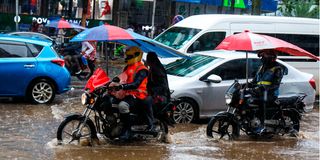
Bodaboda operators pass through a flooded section of Junda area after heavy downpour in Mombasa on April 22, 2026.
Photo credit: Kevin Odit | Nation Media Group
National Climate Outlook Forum is responsible for refining the forecast and identifying where impacts are most likely, allowing different sectors to prepare accordingly.