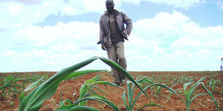
An unusual combination of atmospheric conditions and regional geography is behind the suppressed rainfall being recorded in Eldoret and the wider North Rift, a senior meteorologist has revealed.
Speaking in an exclusive interview with Climate Action , David Koros, Assistant Director of Forecasting Services at the Kenya Meteorological Services Authority (KMSA), said the region’s delayed rains are not a coincidence, but the result of multiple interacting weather systems.
“The suppressed rainfall observed over Eldoret and the North Rift during the expected onset period,” Koros explained, “can be attributed to the combined influence of unfavourable atmospheric circulation and local topographic effects.”
According to Koros, dry north-easterly winds at mid-levels of the atmosphere have cut off the flow of moisture from the Congo Basin — a key source of rainfall for Kenya. At the same time, weak low-level wind convergence has further reduced the likelihood of cloud formation.
The situation is being worsened by the region’s landscape. Koros noted that prevailing wind patterns interacting with terrain features have limited orographic uplift — where moist air rises over high ground to form rain — particularly on leeward sides.
A temperature inversion, linked to sinking air and downslope warming along the Kerio Escarpment, has further stabilised the atmosphere. This condition effectively caps vertical air movement, preventing the development of rain-bearing clouds.
“These factors have created a stable atmospheric environment that suppresses vertical motion and inhibits rainfall formation,” he said.
Despite the official onset of the rainy season, Koros noted that conditions remain largely unfavourable for sustained convection, explaining the continued dry spell across the agriculturally vital region.
The delayed rains are likely to raise concerns among farmers in the North Rift, often referred to as Kenya’s grain basket, as planting calendars and crop yields depend heavily on timely and consistent rainfall.
Even as parts of the North Rift remain dry, the KMSA projects continued rainfall across several parts of the country.
“Rainfall is expected to continue in several parts of the country, most notably the Highlands East and West of the Rift Valley, the Rift Valley, the Coast and Northeastern Kenya,” KMSA stated. “Heavy rainfall events are likely to occur in some parts of these regions.”
Daytime temperatures are likely to exceed 30°C in the Coast, the southeastern lowlands and northern regions, while night-time temperatures could fall below 10°C in parts of the Highlands East of the Rift Valley, the Central Rift Valley and areas near Mount Kilimanjaro.
In the Highlands West of the Rift Valley and the Lake Victoria Basin, including counties such as Uasin Gishu, Kakamega, Kisumu and Narok, morning rains are expected in a few areas, followed by afternoon showers and thunderstorms across several locations.
While thunderstorms are typical during Kenya’s long rains season, Koros warned that some are becoming more intense.
“Thunderstorms are common at this time of year because of strong heating and high humidity, but some may appear more erratic due to changing climate patterns,” he said.
“They produce lightning, heavy rainfall, strong winds and can lead to flash floods, which have recently caused fatalities in several counties,” he warned.
“Warmer temperatures increase evaporation and atmospheric moisture, meaning storms can produce heavier rainfall and stronger lightning activity, making extreme events more frequent and less predictable.”
A similar pattern is forecast for northwestern counties such as Turkana and Samburu, particularly in the first half of the outlook period, with intermittent rainfall expected at different times of the day.
In the Highlands East of the Rift Valley, including Nairobi and surrounding counties, morning rains are likely early in the forecast period, with afternoon thunderstorms becoming more widespread and occasional night showers extending to several areas.
For northeastern counties such as Mandera and Wajir, as well as parts of the southeastern lowlands including Machakos and Kajiado, rainfall is expected to remain scattered.