Premium
Kenya on high alert as cyclone hits Tanzanian coast

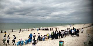
Clouds gather on the horizon along the Kenyan coast at Nyali Beach in Mombasa County. Weatherman says the coastal areas are likely to experience depressed rainfall.
Current observations indicate that Tropical Cyclone Hidaya has hit the Tanzanian coast, triggering a high alert by the Kenyan authorities.
A landfall in this context, the Kenya Meteorological Department Director David Gikungu, explains it is the centre of the circulation of the storm coming inland.
“It will cause disturbances and we expect it to disintegrate. However, we are still monitoring it and even getting reports from our Tanzanian counterparts,” Gikungu said.
As close monitoring continues, KMDurged residents, particularly in coastal regions and individuals involved in marine activities in the Indian Ocean, to take maximum precautions.
Heavy rainfall is expected offshore along the Kenyan coast from Sunday, May 5, intensifying on Monday, May 6, to Tuesday next week.
The effects of the cyclones are already being felt offshore, with strong winds exceeding 40 knots (20.6 m/s) and large waves surpassing two metres.
Banned fishing
Already, Kenya has banned fishing, swimming, non-essential transport, and other beach activities from May 4 to May 6 at midnight, when the effects of the cyclone, were it to hit, will have ended.
In a statement, Interior Cabinet Secretary Kithure Kindiki announced a ban on all non-essential activities within Kenya’s territorial waters, along the beaches and settlements adjacent to the shoreline.
“The Government cautions members of the public engaged in fishing, swimming and leisure activities within Kenya’s territorial waters and the beaches of Kwale, Mombasa, Kilifi and Lamu Counties that available scientific information points to the possibility of risk to life and property within these areas,” said Prof Kindiki.
If the cyclone hits Kenya, Prof Kindiki said, it could generate massive precipitation with strong winds and powerful waves capable of significantly disrupting normal activities within Kenya’s territorial waters in the Indian Ocean and human settlements along the Kenyan Coast.
“The County Security and Intelligence Committees (CSICs) of Kwale, Mombasa, Kilifi and Lamu Counties in collaboration with the Kenya Coast Guard Service(KCGS) are directed to immediately issue notices and to strictly enforce a ban on beach activities, fishing, swimming, non-essential transport within Kenya’s territorial waters and evacuate settlements deemed too close to the shoreline effective today, May 4, 2024, at 5pm up to and until midnight on Monday, May 6, 2024, when Cyclone Hidaya is expected to expire,” Prof Kindiki announced.
Tanzanian counterparts
In a statement issued by the Tanzanian counterparts, Tanzania Meteorological Authority, on Saturday, tropical cyclone Hidaya was close to the coast of Tanzania and has continued to dominate weather systems in those areas.
“Over the past 6 hours, periods of heavy rain and strong winds have continued to occur. For instance, at the Mtwara, Kilwa, Zanzibar, and Dar es Salaam weather stations, strong winds exceeding 50 kilometres per hour were recorded at different times from last night to this morning.
In addition, during the same period, heavy rains have continued to be witnessed in the Mtwara and Lindi regions, whereby at 9 pm last night, the Mtwara station reported 75.5 millimetres of rain within 12 hours.
This amount of rainfall within 12 hours is very high, considering that the average rainfall for May at the Mtwara station is only 54 millimetres.
Therefore, the amount of rain that fell within 12 hours at the Mtwara station is approximately 140% of the average rainfall for May at the Mtwara station,” read the statement.
In addition, the cyclone is expected to continue moving closer to the coastal strip of Tanzania while gradually weakening towards the night of Saturday, May 5, 2024, the statement added.
KMD says it will continue to issue updates as necessary.


