The rain that fell on Chesongoch in the last week of October was not unusual because it was heavy. It was extraordinary because it was nearly three times heavier than it should have been.
The data was warning enough. Meteorologists issued alerts across 46 counties. Scientists could map which hillsides were vulnerable. But when 40 people died in a landslide that buried the valley of Chesongoch, it raised a harder question than whether it could have been predicted: Why wasn't the prediction enough to save them?
Over a 10-day period from October 23 to November 1, the valley received 47.1 millimetres of rain, a figure that sits grimly alongside a quarter-century of data.
Photo credit: Pool
Over a 10-day period from October 23 to November 1, the valley received 47.1 millimetres of rain, a figure that sits grimly alongside a quarter-century of data. The historical average for those same 10 days, measured across 24 years, is just 13.4 millimetres. When scientists and meteorologists now look back at what happened on the night of October 31, when a hillside above the town of Chesongoch suddenly gave way, killing more than 30 people and displacing hundreds more, they see that anomaly glowing in their data: plus 250.7 per cent above baseline. Nearly two and a half times normal rain.
It was not one catastrophic downpour, but rather the persistence of that moisture, rain coming in intense bursts followed by lighter showers that transformed the soil into a kind of wet, heavy clay, unable to hold itself on slopes that nature had already tilted to the breaking point.
The landslide that devastated villages in Elgeyo Marakwet County in the Rift Valley was neither a complete surprise to meteorologists nor an unpredictable act of God. The rainfall that triggered it arrived with a warning. The topography that made it inevitable was written into the landscape long before the first heavy cloud formed. And yet, on that October night, it came anyway, a catastrophe born from data that was visible, and soil that could no longer hold on.
A hill that was waiting to fail
Elkana Kipruto and Eugene Tulu, the scientists who conducted a topographical assessment of the disaster in its aftermath, found something revealing in their measurements of the failed slope. The terrain that collapsed was, on average, 28.8 degrees steep, a pitch that is almost three times steeper than the surrounding landscape, which averaged just 8.7 degrees. Kipruto and Tulu are geospatial and remote sensing experts. They arrived at the numbers by studying satellite data.
It was not one catastrophic downpour, but rather the persistence of that moisture, rain coming in intense bursts followed by lighter showers that transformed the soil into a kind of wet, heavy clay, unable to hold itself on slopes that nature had already tilted to the breaking point.
Photo credit: Pool
"The slope that failed is around three times steeper than most of the ground around it," they noted in their report, shared exclusively with the Nation. "Such angles store a lot of gravitational stress, meaning the hillside becomes highly sensitive once the soil weakens," they said.
This is the paradox of landslides. A steep slope alone does not guarantee failure. Thousands of hillsides around the world tilt at similar angles, day after day, year after year, without moving. What makes the difference is when other conditions align, when the soil becomes saturated, when the pore spaces fill with water, when the material loses its grip.
The scientists examined other potential triggers. They looked at the Topographic Wetness Index, a measure of how naturally water collects on a piece of land based on its shape. They looked at flow accumulation, a calculation of how water concentrates as it moves downhill. These measures revealed something important: the landslide did not begin in a valley or drainage channel. It was not a consequence of prolonged erosion by flowing water working its way into the slope, week after week, month after month.
The warnings were specific, repeated, and public. They were issued through media and so
Photo credit: Pool
"The failure was likely not due to prolonged flowing water eroding the slope," Kipruto and Tulu concluded. "Instead, the most plausible trigger is short, intense bursts of rain falling on soil that was already wet."
The pattern that preceded disaster
On October 25, the rains began in earnest. Over three consecutive days, from October 25 to October 27, Chesongoch recorded 15.2 millimetres, 8.5 millimetres, and 8.2 millimetres of rain. The heaviest single burst came on the first day, a downpour so intense it pushed the water deeper into the ground faster than the soil could drain. After October 27, the rain diminished but did not stop. Light showers continued to fall, keeping the soil saturated, preventing it from drying, maintaining that critical state of wetness. By the hourly data that meteorological instruments recorded, the pattern became even more dramatic. In one six-hour window, 14 millimetres of rain fell, nearly as much as fell over the entire following day. Short, intense bursts followed by continued dampness. The exact conditions that hydrologists know precede saturation-driven slope failures.
The collapse was not gradual. Multiple hillsides that had been steepened by age and geology suddenly gave way.
Photo credit: Pool
"Intense storms quickly fill the soil's pore spaces, and subsequent rainfall prevents drainage," the rainfall analysis noted.
By the time October 31 arrived, Kerio Valley had been soaked for nearly a week.
The warnings that came before
The Kenya Meteorological Department had begun issuing heavy rainfall advisories as early as October 22, more than a week before the disaster struck. That advisory, numbered 03/2025, warned of rainfall potentially exceeding 30 millimetres in 24 hours, with explicit mention of flooding and landslide risks, particularly in the Rift Valley and western Kenya's steep regions.
On October 23, the warning was revised upward. Rainfall would intensify to more than 50 millimetres in 24 hours in some areas. The department urged residents in flood- and landslide-prone regions to move to safer ground and heed local authorities' alerts.
By October 28, the Kenya Meteorological Department had expanded the advisory to cover 46 counties. The agency attributed the sustained rainfall to the Madden-Julian Oscillation, a natural cycle of wind and pressure variation in the tropics, and to Tropical Depression Chenge, which had enhanced rainfall activity over Kenya. The advisory cautioned that rainfall intensity could exceed 30 millimetres in 24 hours, with "increasing risks of flooding, landslides, and disruption of transport and daily activities."
The warnings were specific, repeated, and public. They were issued through media and social platforms. Yet when the hillside above Chesongoch gave way around 4am on November 1, not October 31 as initially reported, the slope failed suddenly, catching the community below unawares.
Interior Cabinet Secretary Kipchumba Murkomen later urged residents in Kerio Valley to "heed early warning alerts and move to safer ground." But for those living on the land that had become precious to them, sometimes warnings are not enough. Sometimes warnings come to a place where alternatives do not exist.
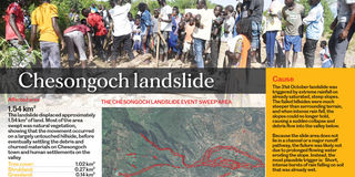
The collapse was not gradual. Multiple hillsides that had been steepened by age and geology suddenly gave way. The mass of saturated soil and vegetation that cascaded down carried with it boulders and debris, moving at devastating speed down toward the valley floor. "The sweep zone, the area actually impacted by the moving debris, covered approximately 1.54 square kilometres. Of that area, about 1.02 square kilometres had been tree cover; another 0.27 square kilometres was shrubland. This was a largely natural hillside, untouched by intensive human modification that descended upon the settlement below," cited the report by Elkana and Tulu.
The rainfall had been extraordinary, among the most extreme in the 25-year historical record, ranking close to the levels observed in 2006.
Photo credit: Pool
Chesongoch and the surrounding villages of Murkutwa, Embobut, and Sambirir had endured warnings, and residents had lived with the knowledge that they occupied a landscape prone to such disasters. The same area had experienced significant landslides in 2010 and 2012. In April 2020, another series of debris flows killed 15 people. The Elgeyo
By dawn on November 1, at least 40 people were dead. The exact count would rise and shift as rescue operations continued. More than 30 people were missing. More than 1,000 homes had been destroyed or buried. The Kenya Red Cross launched emergency air evacuations for those most severely injured, coordinating with military and police helicopters to transport the wounded to hospitals in Eldoret. Rescue efforts were repeatedly suspended due to continued rainfall and blocked roads.
"Access to some of the affected areas remains extremely difficult due to flooding and blocked routes," the Kenya Red Cross reported.
The science after the fact
In the days that followed, scientists and meteorologists constructed the timeline of what had happened. The rainfall had been extraordinary, among the most extreme in the 25-year historical record, ranking close to the levels observed in 2006. The intensity and pattern had been exactly what hydrological theory predicted would destabilise a steep, already-saturated slope. The topography had been ripe for failure.
The Kenya Meteorological Department later acknowledged the rainfall's role directly. According to a statement released after the disaster, "the sustained October rainfall led to soil saturation and flooding, particularly in western Kenya." The agency maintained that it had continued to issue "regular advisories and updates through media and social platforms to guide decision-making and mitigate risks."
Yet for all the data and the warnings, the hillside fell. The soil gave way. The rain that came at nearly 2.5 times the historical average did what such rain does when it meets already-saturated ground on a slope angled toward collapse.
In the days since October 31, or rather, November 1, as the precise date has been recorded, officials have begun to discuss not just the immediate disaster but the reasons Chesongoch remains so vulnerable.
CS Murkomen attributed the increasing frequency and severity of landslides in the region to multiple factors: the Elgeyo Escarpment's inherently steep and unstable geology, intense rainfall linked to climate change, and widespread environmental degradation. "The biggest problem with this issue is deforestation, the problem of landlessness," he noted after the disaster. Poor farming practices on vulnerable slopes had worsened the situation.
The land itself had become a wound. Tree cover that might have helped stabilise slopes had been stripped away. Communities living on steep terrain with insecure land tenure, unable to own property collectively or individually, had built homes in increasingly precarious locations. The scale of disaster shifted each time conditions aligned.
On November 21, more than three weeks after the disaster, 31 victims were buried in a mass grave at St. Benedict Christ the King Catholic Church in Chesongoch. Families whose own lands had been buried under boulders and debris, whose homes had been washed away, gathered to grieve. The process of rebuilding had begun, but many who survived, and many whose land had been destroyed, were already contemplating leaving the valley entirely.
The rain had passed. But the questions remained: What makes a warning enough? What happens when people cannot move to safer ground because there is nowhere else to go? And when the next heavy rainfall comes, as climate patterns suggest it will, how many warnings must fall on the same steep slopes before something changes?