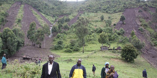
As heavy rains continue pounding Kenya's highlands, deadly landslides in Elgeyo Marakwet County have claimed at least 30 lives, displaced families, and destroyed homes and infrastructure.
Behind the destruction lies a complex mix of geology, climate change, and decades of human activity that have made the region's fragile escarpments far more unstable. To understand how this disaster unfolded, let's begin by understanding the land itself.
Elgeyo Escarpment is one of Kenya's most dramatic geological features, a steep, straight formation on the western side of Rift Valley. Its base consists of ancient metamorphic rock, among the hardest in Kenya, while its upper layers are younger volcanic materials forming the Uasin Gishu Plateau, which tilts slightly westward, channeling water into rivers like the Nzoia and Yala.
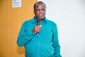
To unpack this, Nation spoke to Prof Simon Onywere, a geologist, and acting director of the Kenya Meteorological Department (KMD) Edward Muriuki, who both shed light on the root causes of the disaster and the urgent measures needed to save lives in the future.
"It is a very steep and fragile feature," says Prof Simon Onywere. "One cannot imagine that for any reason whatsoever, anybody has been allowed to settle there."
Originally, the escarpment was heavily forested as part of Cherangany Forest system, a vital water tower that fed the region's rivers. But over the decades, large parts of this forest were cleared for farming and settlement.
How human activity accelerated instability
The escalating landslides are not purely natural disasters. Two primary human activities have significantly destabilised the region's fragile escarpments: settlement and cultivation.
Many residents have built homes directly on steep hillsides. To construct these houses, they first carve out flat surfaces, called benches, by cutting into the hillside. This creates a vertical wall that weakens the slope beneath the house. "The moment you create a wall, you have already created an unstable slope," Prof Onywere explains. "Gravity keeps pulling on the mass above, and when water seeps in, it adds weight and lubricates the soil, causing the whole section to creep or shear off."
When rainwater accumulates in these weakened layers, especially where solid rock prevents downward drainage, the result is often catastrophic. The saturated mass eventually gives way, sending tonnes of soil and debris crashing downhill.
Residents often cultivate crops like maize on steep slopes without terracing or soil-stabilising structures. The water has no time to filter into the soil; it simply runs off, carrying topsoil with it. Over time, this force of runoff water carves channels that deepen with every rainy season, stripping away the earth and destabilising the slopes further.
"These land use activities are a big contributor to the problem," Prof Onywere stresses.
Why people live on dangerous slopes
Despite the risks, many families remain on the escarpment not by choice, but by circumstance. Historical conflicts between neighbouring communities forced people to settle on higher ground.
"The Marakwet people said it was safer for them to stay in the mountains," Prof Onywere explains. "In the valleys, they would be attacked, and their animals stolen by their rivals."
Over time, pastoral communities shifted toward farming on steep slopes, trading one form of risk for another.
"Circumstances forced them to stay up the slopes because that's where they were safer," he says. "But that safety from human conflict has now turned into exposure to environmental danger."
The failed warning system
For years, Kenyan scientists have conducted extensive research identifying high-risk zones across the country. A comprehensive national risk and hazard vulnerability assessment, led by Kenyatta University and supported by the United Nations Development Programme, mapped out vulnerable landscapes and recommended safety measures. The study, conducted after the devastating 2009 drought, traversed the entire country, documenting environmental vulnerabilities from the Coast to Rift Valley.
At the time, researchers warned that the slopes of Elgeyo Marakwet were ‘not inhabitable’. Settlements on the escarpment, they wrote, should not be allowed because the terrain was unstable and prone to disaster. Yet over a decade later, communities still live and perish on those same slopes.
"What happened to those reports? What happened to the recommendations?" Prof Onywere asks. The gap between research and policy execution remains stark. "In the first place, they should not have settled there. In the second place, they should not have been allowed to settle there."
Prof Onywere believes that many residents simply lack awareness of the risks, and the responsibility lies with authorities to enforce land-use laws.
“Somebody must come and tell a resident, ‘No, you can’t live here because this is a conservation area. That’s what the government is supposed to do.”
“We have clauses in our laws that define areas that cannot be settled because of their topography,” he explains. “Such land should remain public and untouched.”
Agencies like National Environment Management Authority and the Water Resources Authority are mandated to oversee such zones while the Ministry of
“Who takes responsibility? How did we look the other way when people were allowed to settle in risky areas?” he asks.
But enforcement has been weak, allowing communities to settle in unsafe areas.
Similar situations, he notes, have occurred elsewhere like in Baringo, where communities displaced by conflict now live near lake plains and riparian zones, exposed to floods and waterborne hazards.
This was even after a study that examined flooding around lakes Baringo and Bogoria offered recommendations to improve community resilience.
“The information was meant to be shared with counties so that they could take action,” Onywere says. “But implementation has been slow.”
Local leaders have also sent mixed messages. Some officials, especially from the Ministry of Interior, have publicly urged residents to move to ‘higher ground’ to avoid floods.
However, according to Prof Onywere, the advice oversimplifies the problem.
“They say move from low lying areas prone to floods to higher ground,” he states, “but which higher ground? And are those areas any safer?”
According to Mr Muriuki, the current landslides result from excessive rainfall combined with geological instability.
“A landslide is a mass of moving ground, soil, rock or debris down a slope. It occurs when gravitational force exceeds the force that holds the ground together.”
The area has been experiencing unusually high rainfall amounts since mid-year. Even the typically dry June–August period recorded heavy rains, leaving the ground saturated before the October–December season began.
"So, already the season commenced when the ground was saturated," he says. "That is what caused it."
"Due to climate change, we are seeing more frequent extreme weather events. We are seeing prolonged droughts and heavier rainfall episodes, even during months that were previously dry."
KMD uses advanced forecasting models, including numerical weather prediction and machine learning, to enhance accuracy. At the county level, each region has a County Director of Meteorology responsible for localised forecasts and working with county disaster management committees.
KMD often releases extreme weather advisories that sometimes predict flooding or landslide events, forecasts that are then handed over to the Interior ministry for action. Just before the tragedy in Chesongoch, a heavy rain warning had been issued, with possibilities of landslides listed.
"There could be challenges," Mr Muriuki acknowledges. "Vulnerable communities have other challenges such as poor network coverage, lack of access to telephones or radio, and limited reach of local FM stations."
According to the geologist, forecasts for the coming weeks suggest a slight reduction in rainfall, but another surge is expected later in the season.
“As to whether there will be similar incidents, I may not be able to say with certainty,” he says. “But it is good for residents to be cautious.”
To address the last-mile communication challenge, KMD is completing the installation of weather infrastructure in Kerio Valley. The department is working with county government to establish a community radio network to relay forecasts and advisories in local dialects. "It will enhance reachability," Mr Muriuki notes, emphasising that community radios are cost-effective and trusted as direct communication channels for local communities.
But infrastructure alone won't solve the problem. Prof Onywere cautions against false optimism about Kenya's forest recovery. "We claim to have recovered up to 14 per cent forest cover. But from what I have seen in satellite images, we are still around two per cent. Real forest recovery takes decades."