Meru village attracts visitors after being marked Kenya's 'centre'

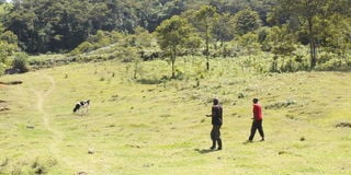
Nyambene forest, overlooking Nthangathi village in Igembe South, Meru which hosts what is beloved to be Kenya's Geographic Centre.
Riaki village, the neighbourhood of Igembe South MP John Paul Mwirigi, previously made news because of high cancer cases, but today it is because of a tourist attraction.
Travel enthusiasts, professionals and students of geography have been trooping to Nthangathi village in Riaki at the edge of the Nyambene forest to visit ‘Kenya’s Geographic Centre’.
This is after Mr Brian Njagi, a travel enthusiast, made his calculations and determined Kenya’s geographic centre to be at a point within Mr Kinyua M’Ikiani’s farm.
The farm is the last settlement along the Nyambene forest reserve.
According to Mr Njagi, who is trained in communication, Kenya’s geographical centre sits on coordinates 0.1765°N, 37.913°E, some 43km from Meru town and 1.5km from Aathi market on the Mikinduri-Maua road.
“I was just curious what the geographical centre of Kenya would be. I did a Google search and found nothing. I then did some online research and learnt how to find the geographic centre. Today, if you search ‘Kenya’s Geographic Centre’ on Google, you will find the spot,” Mr Njagi says.
He says he used a paper cut out of the map of Kenya and balanced it on a nail.

Joseph Gituma points to the location believed to be the geographic centre of Kenya at Nthangathi in Igembe South, Meru.
“The map cut out balanced at a point somewhere near the border of Meru and Isiolo counties. However, this is never the best way of finding the centre,” he explains.
Mr Njagi adds: “With the help of my wife, who is an economist, and a friend, Dennis Kimathi, who is a statistician, we used a mathematical method I found online.”
He says they used the coordinates of the four extreme ends of Kenya before finding the average.
“We added the longitudes and divided them by two and did the same with the latitudes. What you get is the central coordinate,” he said.
Mr Njagi says his calculations included the Ilemi triangle, which is contested, and left out the ocean as he did not have the coordinates for the international water boundary.
Armed with the average longitude and latitude, Mr Njagi and two friends embarked on the journey to mark the ‘centre’ on December 27 last year.
“We used two phones to reduce errors and find our way to the destination. At the exact spot where the coordinates led us, a grove of four banana plants ring-fenced the central point of Kenya. We planted a euphorbia shrub and accomplished our mission,” Mr Njagi says.

Joseph Mutuma and his brother tend for the euphorbia plant which marks the point believed to be the geographic centre of Kenya at Nthangathi in Igembe South, Meru. PHOTO/ DAVID MUCHUI
Mr Joseph Mutuma, whose family owns the land, said they have received several groups of visitors since Mr Njagi marked their farm as the centre of Kenya.
“We have had a group of lawyers, university students and many others come to see the centre. We may have to stop farming here because visitors have been trampling on crops,” Mr Mutuma said.
He says they are also considering charging an entry fee for curious visitors.
While a geographic centre has no real world correlation, it places some aesthetic value to a place just like the equator line has become a major tourist attraction.
Since the essence of devolution was to bring services closer to the people, the geographical centre of counties was at the centre of debate in determining the headquarters.
In 2014, the Laikipia County Assembly endorsed the relocation of the county headquarters from Nanyuki to Rumuruti, which they argued was centrally located.
Ten years later, Tharaka Nithi County, which chose Kathwana as the most central location for its headquarters, is yet to complete construction of offices.
The manifesto of 2022 Roots Party presidential candidate George Wajackoyah included relocating Kenya’s capital Nairobi to Isiolo, arguing that it sits at the centre of Kenya.
"Isiolo is the centre of Kenya. Making Isiolo Kenya’s administrative centre is the same as making Canberra Australia’s capital," Mr Wajackoyah said.
North America has had monuments marking its geographic centre since the 1920s, but this has changed several times as more territories were added.

Map showing Kenya's geographical center
According to the Smithsonian Magazine, a United States Geological Survey mathematician determined the geographic centre of North America in 1928 by balancing a cardboard cutout of the continent on a pin.
In 2017, Peter Rogerson, an American geography professor, developed a method for determining geographic centres, moving the existing centre by more than 230 km.


