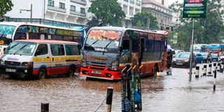
A total of 246 areas in Nairobi County have been mapped out as potential hotspots to be hit hard by flooding during the October-December short rains season.
The Kenya Meteorological Service Authority has predicted that the country will experience above-average and wetter-than-normal conditions during the rains.
In preparations to mitigate the impact of the El Nino phenomenon, which is expected to be accompanied by heavy rains, and floods, the National Disaster Operation Centre (NDOC), Kenya Red Cross, and Nairobi County Disaster Management sector have identified some of areas in the city which will be affected.
A man wades through a flooded section of Moi Avenue in Nairobi on March 20, 2026, following heavy rainfall.
Photo credit: Bonface Bogita | Nation Media Group
According to Nairobi County Chief Officer in charge of Disaster Management Bramwel Simiyu, the county has embarked on clearing drainages and all waterways to ensure that there is no blockage to the storm water.
Some of the major roads which are to experience floods includes Uhuru Highway, Jogoo Road, Kangundo Road, Thika Road, and some roads in Westlands.
“Our focus is on mitigation and preparation at this point in time but also preparing our response perspective to be ready, and in the worst case scenario, to help those who will be affected,” Mr Simiyu said.
Among the hotspot areas which require humanitarian impact includes Mukuru informal settlements and the Industrial Area corridor which is made up of Pipeline, Imara Daima, and Kware.
The second corridor comprises Gatina, Waruku, and some parts of Waithaka. The estates around Nairobi Dam including some parts of Lang’ata, and Kibra have been also categorised as places to witness floods based on the historical occurrence.
“The medium case scenario is about 22,000 to 25,000 households that we anticipate to be affected. We are also projecting the worst case scenario of up to 100,000 households that will be affected and we are prepared for that,” Mr Simiyu said, adding that the committee has identified some of the areas including schools which will be used as holding areas.
Other than having the rescue team on standby, the chief officer said that emergency lines, boats, and relief support will be available to rescue people in case their homes are marooned.
The Nairobi Central Business District (CBD) is also expected to witness floods based on historical occurrence, which the county government said will be monitored to ensure that mitigation measures are put in place.
Pedestrians cross a flooded section of Kenyatta Avenue in Nairobi following rains on January 26, 2025.
Photo credit: Dennis Onsongo | Nation Media Group
This comes days after the Principal Secretary for Health Mary Muthoni said that El Nino contingency plans have been rolled out to provide a common framework for national and county governments, emergency agencies, humanitarian organisations and development partners to anticipate, prevent, detect and respond rapidly to flood-related health emergencies.
In her statement, the PS said that particular attention is being given to water and food-borne diseases, including typhoid, cholera, dysentery, hepatitis A and other diarrhoeal illnesses, which can increase when floodwater contaminates drinking water sources and sanitation systems.
“Through the National Health Sector El Niño Task Force and emergency operations structures, partners are supporting joint planning, rapid assessments, emergency medical services, referral and evacuation, community outreach, risk communication, relief support and assistance to vulnerable populations,” the PS said.
Kenyans have been asked to continue observing evacuation and safety instructions, avoid walking or driving through floodwater, and rely on information issued by the Ministry of Health, county governments and authorised emergency agencies.