Inside Kenya's only quaking bog fighting for survival
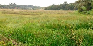
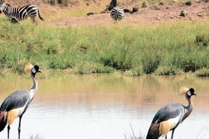
A section of Ondiri Swamp in Kikuyu, Kiambu County on September 25, 2025.

What you need to know:
- Formed thousands of years ago from a volcanic crater lake, Ondiri evolved into one of the few documented tropical quaking bogs worldwide.
- This natural sponge absorbs floodwaters, filters pollutants, stores carbon deep within its ancient peat layers, and regulates water flow throughout the year.
Step onto Ondiri Swamp, and the ground trembles beneath your feet, not from fear, but from physics. This spongy, floating mat of vegetation literally quakes when you walk on it, earning its name from the Kikuyu word for "drizzle" or "wetness."
Just 30 minutes from Nairobi's CBD, this 34.5-hectare wetland is Kenya's only known quaking bog and a vital lifeline for over 450,000 people across Kikuyu, parts of Nairobi, and surrounding regions.
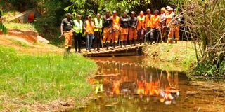
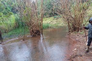
Friends of Ondiri posing next to a Nairobi river tribunary at Ondiri swamp in Kikuyu, Kiambu County. Photo I
Formed thousands of years ago from a volcanic crater lake, Ondiri evolved into one of the few documented tropical quaking bogs worldwide. This natural sponge absorbs floodwaters, filters pollutants, stores carbon deep within its ancient peat layers, and regulates water flow throughout the year. It sustains the Nairobi River Basin and supplies clean water as far downstream as State House itself.
Why Nairobi can't afford to lose Ondiri
In a country grappling with rapid urbanisation and increasingly erratic rainfall, this swamp plays a disproportionately large role in water security.
Peter Nganga, project manager at Kikuyu Water Company, explains that Ondiri's twin borehole site supplies approximately 60,000 people, contributing nearly half of the company's total water production. The swamp also recharges Kikuyu Springs, which supply Nairobi with around 6,000 cubic metres of water daily—enough to fill two Olympic-sized swimming pools.
"Without Ondiri, we would be staring at a water crisis," Nganga says plainly. Globally, quaking bogs are rare, mostly confined to colder climates in Ireland, Scotland, Canada, and Siberia. Finding one on the equator makes Ondiri both uniquely valuable and dangerously vulnerable. Kenya has lost nearly 40 per cent of its wetland cover in the last 50 years, according to Nature Kenya.
Despite its importance, Ondiri faces mounting threats. Encroachment from expanding Kikuyu and Nairobi is squeezing the swamp's buffer zones. Informal settlements and farming activities now creep within metres of the wetland boundary.
During rains, stormwater runoff carries plastics, sewage, oil residues, and agricultural chemicals into the swamp. Recent volunteers collected over 200 kilogrammes of plastic waste in a single morning.
Unregulated borehole drilling and peat soil extraction for horticulture further disrupt its hydrology. Peat takes thousands of years to accumulate; once removed, it cannot regenerate within human lifespans.
Samwel Lepokoiyit, county director for Nairobi at the National Environment Management Authority (Nema), doesn't mince words: "Ondiri is the heart of Nairobi's water supply. Losing it would mean losing clean water for millions of people."
Agricultural degradation poses a particularly insidious threat. Farmers clearing peat soils for maise, napier grass, and arrowroot destabilise the swamp's base, compromising its ability to retain soil and filter water. The practice also releases stored carbon, turning a climate solution into a climate problem.
Nema is pushing for Ondiri to be officially gazetted as a protected wetland. This legal designation would strengthen enforcement and unlock government funding.
"We are finalising an Integrated Management Plan with all stakeholders," Lepokoiyit explains. "Gazettement will give us the legal teeth to protect Ondiri from further
encroachment. Without it, we're fighting with one hand tied behind our backs."
Formal protection would also open doors to international funding for restoration projects, buffer zone rehabilitation, and public education campaigns.
Community power: From dumping ground to sacred ground
The local community has mobilised with remarkable energy. Dr Daniel Wakogy, founder of Friends of Ondiri, leads a coalition of schools, churches, and youth groups in monthly cleanups, tree planting, and advocacy.
"Ten years ago, people treated Ondiri as a dumping ground," Wakogy recalls. "Today, they recognise it as a source of life and pride."
Youth groups have been especially dynamic, creating viral TikTok videos of the quaking surface, organising nature walks for Nairobi residents (charging Sh500 per person), and using social media to spread awareness.
Julie Mulonga, director of Wetlands International for Eastern Africa, emphasises the importance of science-based restoration. "Wetlands act as natural shock absorbers—swallowing floods and releasing water during droughts," she explains. "But restoration must use native plants and respect natural water flows."
Kikuyu Water Company has emerged as an essential conservation partner. Beyond operating boreholes, the company has planted over 5,000 indigenous tree seedlings along the swamp's edges over three years and distributed seedlings to farmers. In a bold move, the company reclaimed illegally grabbed land near the swamp and converted it into a solar-powered green energy farm.
"Conservation must involve the community—not just in labour, but in decision-making and benefits," Nganga insists. "We also need a structured compensation framework for riparian landowners who sacrifice income to preserve the wetland."
When the wells run dry
For residents, the stakes are personal. Njoroge Kaniaru, 68, who has lived near Ondiri for four decades, remembers when the water table was higher. "We used to have a stream running through our shamba year-round," he says. "Now, it only flows after heavy rains. Without this water, our livelihoods disappear."
Martha Njoroge, a small-scale farmer, draws nearly 2,000 litres daily from nearby springs. "If Ondiri dries up, so does my ability to support my family," she says. "No water means no vegetables, no milk, no school fees."
Ondiri is a paradox, trembling beneath your feet, yet vital to the regional ecosystem. It purifies water, moderates climate, stores thousands of tonnes of carbon, supports biodiversity, and provides livelihoods. But its survival depends on an unprecedented united front: science, funding, legislation, enforcement, and sustained local
stewardship.
"Saving Ondiri isn't just about protecting a swamp," Lepokoiyit emphasises. "It's about protecting public health, water security, and the economic future of this region."
Ondiri by the numbers
Location: Kikuyu, Kiambu County (20km from Nairobi CBD)
Size: 34.5 hectares (approximately 48 football pitches)
Altitude: ~2,000 metres above sea level
Type: Quaking bog (tropical peat wetland)—Kenya's only documented example
People served: Over 450,000 directly and indirectly
Daily water supply to Nairobi: ~6,000 cubic metres (via Kikuyu Springs)
Borehole production: Serves ~60,000 people in Kikuyu town (Kikuyu Water Company)
Trees planted (2021-2024): Over 5,000 indigenous seedlings by Kikuyu Water Company
Plastic waste collected (recent cleanup): 200+ kg in one morning
Kenya's wetland loss (50 years): Approximately 40% of total wetland cover
Kenya's projected population (2030): 70 million
Global quaking bogs: Fewer than 12 documented in tropical regions
Ondiri's age: Thousands of years (formed through volcanic crater transformation)
What makes a bog quake? The science behind ondiri
When you step onto Ondiri Swamp, you're not walking on solid ground, you're walking on a floating mat of vegetation that has taken thousands of years to form.
The formation process:
Ondiri began as a volcanic crater lake, likely formed during the same geological activity that created the Ngong Hills and the wider Rift Valley system. Over millennia,
aquatic plants, such as sedges, mosses, and reeds, grew around the lake's edges, died, and accumulated faster than they could decompose in the waterlogged, oxygen-poor conditions.
This created peat: partially decomposed organic matter that can be metres thick. At Ondiri, the peat layer floats on top of groundwater, creating a spongy, elastic surface.
The vegetation continues to grow on top of this floating mat, with its roots intertwined in a dense network that acts like natural reinforcement.
Why it quakes:
When you walk on the surface, your weight creates waves that travel through the floating mat, much like stepping on a waterbed. The ground literally ripples beneath your feet. This movement gives quaking bogs their name and their distinctive bouncing sensation.
The quaking effect also indicates the bog's health: a well-hydrated, intact peat mat quakes vigorously. If the water table drops or the peat is disturbed, the quaking diminishes—an early warning sign of degradation.
Tropical rarity:
Most quaking bogs exist in cold climates where low temperatures slow decomposition, allowing peat to accumulate. Finding one at the equator, at 2,000 metres altitude where temperatures are cool enough for peat formation, makes Ondiri exceptionally rare. Scientists estimate fewer than a dozen similar tropical quaking bogs exist worldwide.
Carbon storage champion:
Peatlands cover only three per cent of the Earth's land surface but store twice as much carbon as all the world's forests combined. Ondiri's peat layers lock away thousands of tonnes of carbon that would otherwise be released as greenhouse gases. When peat is drained or harvested, it releases this stored carbon, contributing to climate change.
Five other threatened wetlands in Kenya
While Ondiri captures attention for its quaking phenomenon, Kenya’s other wetlands face similar existential threats. Here are five critical sites fighting for survival:
1. Lake Naivasha (Nakuru County)
Size: ~150 km² (varies seasonally)
Threats: Over-abstraction for flower farms, pollution, invasive species
Why it matters: Supports Kenya’s Sh50 billion floriculture industry and over 400 bird species
Status: Ramsar Site (international recognition) but under severe pressure
2. Yala Swamp (Siaya/Busia counties)
Size: Originally ~17,500 hectares (now ~7,000 remaining)
Threats: Large-scale rice farming concessions, drainage schemes
Why it matters: Filters water entering Lake Victoria, supports fishing communities
Status: Lost 60% of area since 2000; ongoing legal battles
3. Lorian Swamp (Garissa County)
Size: ~1,300 km² when flooded
Threats: Climate change, upstream damming of Ewaso Ng’iro River, overgrazing
Why it matters: Critical dry-season grazing for pastoralists; supports rare Somali ostrich
Status: Increasingly drying due to reduced river flow
4. Kuja-Migori Wetlands (Migori County)
Size: ~2,500 hectares
Threats: Gold mining pollution, agricultural encroachment, sand harvesting
Why it matters: Feeds into Lake Victoria; supports migratory birds and fish breeding
Status: Heavily contaminated with mercury from artisanal mining
5. Kinangop Wetlands (Nyandarua County)
Size: ~3,000 hectares (fragmented)
Threats: Peat harvesting for horticulture, potato farming expansion
Why it matters: Source of Malewa River; recharges Lake Naivasha
Status: Rapid degradation; minimal protection enforcement
The common thread:
All these wetlands share similar challenges: weak enforcement of environmental laws, competing economic interests, lack of community compensation for conservation, and insufficient political will. Conservation experts estimate Kenya needs to invest at least Sh10 billion annually to restore and protect its remaining wetlands—a fraction of the economic value they provide through water regulation, flood control, and fisheries support.
Sources: Nature Kenya, Kenya Wetlands Atlas, 2023, National Environment Management Authority (NEMA), State of Environment Report, 2023, Ramsar Convention Database, 2024
Lake Naivasha Growers Group, 2024, Centre for Biodiversity, National Museums of Kenya, 2023, Friends of Ondiri field data, 2024 and
Ramsar Convention on Wetlands, Peatlands Fact Sheet, 2024