Premium
How colonial deals gave rise to bloodbath in 'wild north'

A gun in a house in Turkana North. CHEBOITE KIGEN | NATION
Measuring hundreds of acres, the rich grazing lands of Kasarani, a name coined from the Swahili word "kisirani", is one of the areas you will never see cows and goats graze, even in the driest of the seasons.
The land, which is filled with skulls, opens up to Kibish, a town on the northernmost tip of Turkana County where communities frequently stage deadly raids over land, cattle and water.
“You have to drive very fast here to avoid being an easy target,” Mr Sepai Lowoi, a Kenya Police Reservist we had hired for our security, said.
Kasarani is on the outskirts of Kibish, a rural town separated from any touch of modernity, that forms part of the many contested areas within the Elemi Triangle, a tri-junctional point connecting Kenya, Ethiopia and South Sudan.
It is a two-day trip from Lodwar by road across 292 kilometres of non-existent roads and no mobile phone network. It requires hired security.
The National Geographic Society classifies Kibish as “one the most remote and ancient inhabited regions left on the planet”.
It is also one of the most dangerous places in Kenya, as the Nation found out.
NOMADIC LIFESTYLE
Apart from the officers at the General Service Unit camp and Kibish police station, everyone here follows an entrenched traditional nomadic lifestyle.
The permanently lush tall grass fed by the waters of River Tarach and streams pouring into Lotagipi and other closely linked smaller swamps signify a place of plenty.
But despite the lengthy dry periods in the whole of Turkana County, no one dares graze in Kibish for fear of being ambushed.
In the years gone by, epic battles have been fought here, pitting communities whose peaceful coexistence was rudely and suddenly interrupted by international borders.
“You cannot see them but they are always hiding in the bushes waiting for their victims,” said Mr Joshua Lemuya, a local, referring to members of the Donyiro, a tribe from southern Ethiopia that also lays claim to the land.
South Sudan and Kenya have claimed the territory, whereas Ethiopia has never made an official claim to any part of the triangle.
Whereas Sudan – before the secession of the South – wanted to batter the region with Ethiopia for the Baro (Beyrou) salient, Kenya holds territorial claim to the triangle in abeyance.
FIREPOWER BASIS
Occupied in rotation, according to who has more firepower between the Toposa of South Sudan, Nyangatom of Ethiopia and the Turkana of Kenya, it is Kibish that gave birth to the modern militarisation by East African tribes.
According to Prof Maurice Amutabi, Vice-Chancellor of Lukenya University who helped us with research material for the ‘Rustlers Paradise’ project, the rush for arms in East Africa, and to a large extent Kenya, began in 1937 when Italians occupied the lower Omo Valley in Ethiopia.
“The Italians incorporated the Donyiro and the Merile in their army and distributed 1,000 rifles among them in order to help stop British counter attacks,” says Prof Amutabi in his paper Land and Conflict in the Elemi Triangle of East Africa.
“Armed with these weapons, the Donyiro and the Merile raided the Turkana in 1937.”
The Turkana lost 300 men. In retaliation, the British recruited 5,000 Turkana, armed them and aided them in attacking the Donyiro.
An arms race between communities living in Kibish was born. It later spread to other semi-arid areas in the wild north.
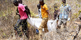
Residents carry the bodies of five people, including three schoolboys, killed in an attack by livestock-stealing bandits in Baringo South. CHEBOITE KIGEN | NATION
The Elemi Triangle, which measures between 10,320 and 14,000 square kilometres – depending on which map you look at – consists of Kibish, Lokitaung, Naita, Karebur, Kokuro, Kaikor, Magila, Lorau and Loruth Esekon.
The dispute over the triangle is also a result of unclear wording of colonial treaties.
On June 17, the Foreign Affairs Ministry signed a Memorandum of Understanding with South Sudan aimed at starting the process of delineating the Elemi Triangle boundaries.
“There have been several bilateral communications since then and both countries are at the stage of appointing individuals to spearhead the process,” Nellie Lodan, a lawyer with the Kenya International Boundaries Office, told the Nation.
Elemi is on the fringe of southern South Sudan, which is believed to be rich in oil, and at the top end of Turkana, a county where oil has recently been discovered.
However, due to decades of insecurity and lack of infrastructure, no exploration has taken place in this contested territory.
ARBITRARY BOUNDARIES
The disputes begin with colonial treaties and arbitrary boundaries which were meant to allow free movement of nomads herding animals but whose framers were vague in their wording.
The vagueness of the 1907 boundary agreements between Ethiopia and British East Africa has contributed to resource conflict.
“Tribes occupying either side of the line shall have a right to use grazing grounds on the other side as in the past, but during their migrations it is understood that they shall be subject to the jurisdiction of the territorial authority,” one clause in the 1907 agreement reads.
“Free access to the wells is equally accorded to the tribes occupying either side of the line.”
The deal was between the United Kingdom and Ethiopia, relative to the frontiers between British East Africa, Uganda and Ethiopia.
It was signed in Addis Ababa by Emperor Menelik II and His Britannic Majesty’s charge d’affaires on December 6, 1907.
“The ‘open frontier’ implied by the clause invited resource conflicts among pastoral people of the newly created national identities during their transhumance and epicyclical movements to dry-season pastures and water,” Dr Nene Mburu, a retired military officer, says in his paper Delimitation Of The Elastic Elemi Triangle: Pastoral Conflicts and Official Indifference in the Horn of Africa.
'CLOSED FRONTIER'
“On the other hand, if the corresponding authorities enforced a ‘closed frontier’, communities that grazed freely before the boundary was drawn, would not honour the exclusion.”
The name Elemi is believed be from a famous chief of the Anuak, a community on South Sudan’s boundary with Ethiopia.
The triangle was named in honour of chief Ilemi Akwon.
The Elemi Triangle is home to the Turkana, Didinga, Toposa, Inyangatom and Dassanach.
These communities are from Ethiopia, Kenya, Uganda and South Sudan, but they traditionally migrate to the triangle to graze their animals.
The Turkana are found in South Sudan and Turkana County while the Didinga are in South Sudan and north eastern Uganda.
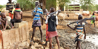
A water collection point in Kibish, the battle field for the Turkana, the Toposa from South Sudan and the Nyangatom and Merille from Ethiopia. CHEBOITE KIGEN | NATION
The traditional enemies of the Turkana and the Didinga are their Inyangatom and Toposa neighbours.
Anthropologists have established a historical connection between the Inyangatom and the Toposa, which points to the two communities having originally been one.
The Inyangatom are found in South Sudan and Ethiopia.
Their neighbours are the Dassanach, who are mainly in Ethiopia, with some in Kenya.
Long before any formal agreements, these communities traded and grazed in the triangle through some kind of arrangements.
They also practised cross-border raids which, among others things, served as a rite of passage for warriors.
It was also a means of regulating the quality of their livestock and a strategy for coping with natural disasters and political domination of neighbours since more animals signified wealth.
All these activities were controlled by a council of elders.
Years later, modern firearms, politics and commercialisation of livestock rustling destroyed the cultural institution that was raiding.
In 1902, the Uganda Order in Council transferred Uganda's Eastern (Rudolph) Province to the British East African Protectorate (Kenya).
The transferred area included much of the present-day Turkana County.
'INTO UGANDA'
“Britain suggested that Elemi should be excised from Sudan and incorporated into Uganda, or, the portion of Uganda’s former Rudolph Province containing the triangle be ceded to Sudan,” the document, Situation on the Sudan-Kenya-Uganda frontier, Draft Order in Council’ Secretariat Minutes, notes.
However, Sudan turned down the proposals.
Subsequently, the 1926 Colony and Protectorate (Boundaries) Order in Council set to redefine the territory between Kenya and Sudan.
“Britain demanded the Turkana of the borderlands should displace further south into the hinterland of the Kenya colony to benefit from British protection, but by so doing, they lost their fertile pastures in Elemi to the Inyangatom and the Dassanach,” Dr Mburu writes.
“By late 1926, Britain had established its administration among the Turkana but their dry season pastures in Elemi were declared a closed frontier where no protection was forthcoming from the coloniser. After 1926, the Kenyan colonial authorities established an administrative boundary that did not coincide with the Anglo-Ethiopian treaty of 1907 as a measure of accommodating Turkana’s ancestral grazing area within Kenya.”
The other that tried to delineate the territories was the Anglo-Ethiopian Agreement of December 6, 1907.
POINT RECTIFICATION
In July 1964, it was suggested that Kenya, Sudan and Uganda rectify tripartite points on the Elemi boundary so as to curb large-scale organised cattle rustling but it was never to be.
In the 1990s, the Ethiopian government armed the Dassanach with new AK-47 rifles in order to protect them from the Turkana and Sudanese cattle thieves.
In 1986, when the Kenyan government published a new atlas including part of the disputed Elemi triangle within its territory, the result was a protest from Khartoum.
The Sudanese government believed that the Sudan People’s Liberation Movement insurgents had traded the lands in the Elemi Triangle with Kenya.
Khartoum said the triangle was part of its Equatorial Province. It armed the Toposa as a way of dealing with the Sudan People's Liberation Army.
When South Sudan gained independence in 2011, the claim to the triangle was transferred to the new government in Juba.
And with that, there has never been peace in the triangle, the capital of East Africa’s fiercest raiders.


