Tropical storm 'Agueda' is interfering with rains, says Kenya Met

Nairobians walk on a waterlogged Kimathi Street following light showers early this month. Experts have warned that the October to December climate forecast shows high chances of wetter-than-usual conditions across most parts of the Greater Horn of Africa region.

As the days go by without the anticipated rainfall in some parts of the country, Kenyans are taking to social media to express their frustration, with some turning to humour while others are growing increasingly anxious. What is happening to the October-November-December rain that was forecast to arrive early in some parts of the country? Why the delay?
It is a question meteorologists at the Kenya Meteorological Services Authority (KMSA) have been working to answer, comparing different weather models and analysing the latest data, now they have a clearer picture of what could be behind the delayed rain.
Hannah Kimani, Director of Public Weather Services at Kenya Meteorological Services Authority (KMSA), partly attributes this to the Intertropical Convergence Zone (ITCZ), a belt of low pressure where winds from the northern and southern hemisphere meet.


“This is the major rain-bearing system that brings rainfall to Kenya during the rainfall seasons as it moves north or south of the Equator.
During the October-November-December (OND) rainfall season, the ITCZ brings rainfall to Kenya as it moves from the northern to the Southern hemisphere. This
This year, the ITCZ started moving Southwards to our country and led to the onset of rainfall over some parts of the country during the first to the second week of October,” she said.
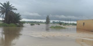
Hundreds of people are reported to have been displaced in the Coast region due to the current heavy rains.
Some stations, in her telling, such as Marsabit, Mandera, Nyeri and Meru, among others, received very heavy amounts of rainfall.
“Most counties over the Coast and some counties over the western half of the country had their onset spreading from September.”
The onset over the remaining parts was expected from the second to the third week of October, except in Turkana and Samburu counties, where onset was expected during the third to fourth week of October.
“The dry weather conditions being experienced currently over some parts of the country when onset was expected to gradually spread to other parts of the country is as a result of a series of low-pressure systems that have developed over the northern Indian Ocean that have temporarily prevented the continuous southward movement of the ITCZ.”
But over the central and eastern parts of the country, the Indian Ocean, a key source of moisture for rainfall, lacked the conditions needed to sustain the expected rains, the meteorologist explained.
The state agency said that the temporarily dry weather conditions are likely to persist till the end of the third week of October, with the exception of the western counties and a few areas around Mount Kenya and the Northeast, particularly areas bordering Ethiopia where rainfall is expected to continue.
Other parts of the country that have not yet had their onsets may occasionally receive rainfall that may not meet the onset criteria during this period.
“Onset refers to the beginning of rainfall that can sustain germination of crops. For an area to be declared to have a rainfall onset, certain criteria must be met. Such an area must receive cumulative rainfall of 20 mm in three consecutive days, and this must not be followed by a dry spell of more than seven days for the next three weeks. This criterion has been met in some parts of the country while others have not yet met this criterion despite receiving occasional rainfall,” she explained.
As to when the rains will start pounding in areas that are still experiencing dry conditions, it remains a wait-and-see situation, with Ms Hannah emphasising that weather forecasting is still a realm of probabilities.

A flooded road in Tudor, Mombasa on December 13, 2021. The Meteorological Department has warned of heavy rainfall.
Now, the authority is closely monitoring a tropical storm “Agueda” that has formed over the South West Indian Ocean that could bring rainfall depending on the trajectory it will follow.
“If it moves north of Madagascar and westward, it will bring us rainfall if other factors are in agreement. If it moves South of Madagascar and westwards, it will worsen the dry weather conditions,” she said. “Since it is still early, we will continue monitoring its movement and issue updates as and when necessary.”
The weekly weather forecast issued on Monday showed us that towards the weekend Kenyans may start experiencing rainfall in pockets of the country, as the preliminary trajectory of the storm may be favourable and improve rainfall over the country.
“And the reason why sometimes it is not very easy to forecast some of these factors is because some of them you cannot be able to forecast with a very long lead time. Like the tropical storms, no centre in the world can tell you that next week or next month expect a tropical storm. We can only monitor once the tropical cyclone forms or how it is moving and where it is moving,” she said.
“And this is the reason our seasonal forecasts are always issued in probabilities. For example, the October-November 2026 rainfall season for Kenya, we gave a 50 per cent probability of enhanced rainfall, 35 per cent probability of near-average rainfall, and a 15 per cent probability of below-average rainfall. And it is because of these many obstacles that we meet along the way that come, and that is why now you can only issue the forecast in terms of probabilities.”
To farmers who are anxious and confused whether to plant or wait for the rain, she said, “Just be ready. What I'm telling farmers is just prepare, and then work very closely with the agriculture extension officers in your respective counties.
They'll be able to advise you on the appropriate seeds to plant, and what other agricultural practices you need to be able to maximise on the expected rainfall, and even to mitigate the negative impacts that the current scenario or even what is expected would come with.”
Meanwhile, in its seasonal outlook, the World Meteorological Organisation said the current El Niño event could be “unprecedented in strength.”
Sea surface temperatures in the tropical Pacific could rise to 3.8 degrees Celsius above average between November 2026 and January 2027, signalling the potential for an exceptionally strong El Niño.
The projected warming is far above the threshold used to identify the climate phenomenon, which occurs when sea surface temperatures in the central and eastern tropical Pacific rise at least 0.5 degrees Celsius above average.
“This is literally off the monitoring charts that we have used for the past four decades. El Niño will peak towards the end of 2026 but its impacts will be felt long after that,” WMO Secretary-General Celeste Saulo said.
The warning comes as countries monitor evolving climate conditions and prepare for the potential effects of El Niño, which can alter rainfall patterns and temperatures in different parts of the world.
A very strong El Niño can bring severe drought to some regions, heavy rainfall and flooding to others, and increased heat across large parts of the world.
In Kenya, the El Niño phenomenon has historically been associated with increased rainfall in some seasons, raising concerns about possible flooding, landslides and damage to infrastructure, crops and livelihoods.
“That explains the above normal temperature that we are experiencing because like we have been saying El Nino is not synonymous to rainfall,” said Ms Kimani.
Follow our WhatsApp channel for breaking news updates and more stories like this.