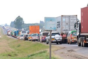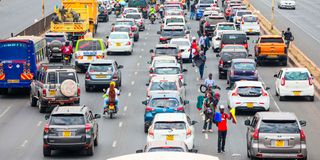
Hawkers sell their wares to motorists stuck in a traffic jam on Thika Road in Nairobi on September 30, 2025.

It was meant to be a railway camp and nothing more. When the Uganda Railway reached the swampy plain in 1899, engineers wanted only a resting spot, a flat terrain where wagons could turn and water could be found. But Nairobi refused to remain a camp. It reinvented itself into a capital. Its roads – initially muddy, improvised and uneven – still whisper the story of division, ambition and resistance to order.
The first roads in Nairobi were an afterthought. What existed was a caravan track – the Uganda route hacked through bush by Sir William Mackinnon’s men, stretching from Mombasa to Kibwezi, and Capt Sclater’s rough road that bore his name, running from Kibwezi to Busia. These were the only paths that could, with some generosity, be called “roads” in the emerging colony.
Everything else was little more than a trail – dust in the dry season, mud in the rains.
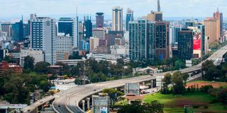
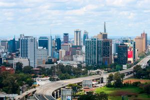
A view of the Nairobi city skyline.
When the railhead finally reached Nairobi on June 5, 1899, Col John Patterson recalled the immense task ahead: to raise a township out of nothing. Houses, bridges, workshops, roads, even a water supply – all had to be imagined, and then hacked into the swamp. To make this camp even faintly hospitable, the responsibility fell to John Ainsworth, the Ukambani provincial administrator who started by planting blue-gum trees, some still visible, along the imagined boulevards.
In 1903, Ainsworth began the painstaking work of linking Nairobi to the surrounding white settlements of Dagoretti, Kiambu and Fort Smith by road. With no cars, Nairobi moved by bicycles, ox carts and rickshaws – the latter especially for women, who were barred from riding bicycles.
Then came the car. In 1902, Maj John Andrew Smith drove into Nairobi with the colony’s first motor vehicle. It was an event so remarkable that within a decade the town boasted not just cars but two garages. Nairobi was no longer just a railway camp; it was a place where engines idled and commerce gathered.
Station Road, Victoria Street (later Government Road, today Moi Avenue) and Sixth Avenue (Kenyatta Avenue) became the town’s first arteries. Sixth Avenue was the boldest of all: wide and straight, a grand commercial boulevard intended to showcase the town’s ambition.
But ambition collided with climate. The roads were unsurfaced and unforgiving – dust storms in the dry months, swamps in the rains.
On one expedition, even former US President Theodore “Ted” Roosevelt found his safari convoy on its way to Macmillan’s Juja Farm stuck in Nairobi’s mud.
The population grew faster than the road network. By 1901, Nairobi’s population was 8,000 and had risen to 11,000 by 1906. From the beginning, the roads told a cruel truth about who belonged where. Roads became the physical expression of hierarchy – the west’s boulevards smooth and shaded, the east’s alleys muddy and narrow.
As policy, Europeans climbed westward into the cooler ridges, building airy homes on wide, tree-lined avenues. Asians clustered near commerce in the town centre and towards Ngara and Pangani. Africans were pushed east into black cotton soils where drainage failed and mosquitoes thrived.
Yet even in this stratified town, there were men like Lionel Douglas Galton-Fenzi – “Dougie” to his friends – who saw roads as arteries of possibility. He founded the Royal East African Automobile Association in 1919. Fenzi believed Nairobi could become the hub of African motoring – “the Clapham Junction of Africa”.
In the 1920s Nairobi, the burden of road-making fell less on the state than on determined individuals. The government, absorbed with its railway, left the interior largely trackless, forcing motorists to improvise.
Hawkers sell their wares to motorists stuck in a traffic jam on Thika Road in Nairobi on September 30, 2025.
When Galton-Fenzi and Capt Gethin set out for Mombasa in a modest 12 HP Riley in 1926, their journey became an act of road-building by machete: hacking through bush, uprooting stumps and dragging their car across a landscape with no roads.
Their struggle – some 15 days and 56 punctures – underscored how little the colonial administration had invested in overland transport beyond the rails.
In the vacuum, Galton-Fenzi effectively became Nairobi’s unofficial roads department. He mapped routes, erected signposts, built rest houses, organised trials and even reported weather conditions – all without government support. These were services that should have been public responsibilities, yet were delivered through private enthusiasm.
Nightmare on roads
For a brief moment, order seemed to arrive on the dusty tracks of East Africa, not because of official policy but because one man and fellow motorists refused to wait for it. They formed the Automobile Association (AA) to do that.
By 1927, Eric Dutton’s blueprint for Nairobi codified segregation into the city’s foundations. The roads ceased to be neutral pathways and became instruments of order and exclusion. Laid out along racial lines, they carved the city into distinct zones, with asphalt and dust demarcating who belonged where.
A road was no longer just a strip of passage; it was a marker of identity and privilege. Europeans enjoyed smooth, tree-lined avenues leading to spacious suburbs, while Africans were shunted into cramped, poorly serviced quarters on the city’s margins.
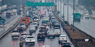
Traffic Jam build up on Thika road towrds Nairobi CBD on March 16,2023.PHOTO|
Roads thus evolved into visible borders of power, making the act of movement itself a declaration of status. To travel on certain streets was to signal entitlement; to be barred from them was to experience Nairobi’s hierarchy written into its very ground. To this day, matatus are not allowed on Muthaiga Road!
In Nairobi, the politics of segregation did not only live in policies or by-laws – they were etched into the roads themselves.
By 1948, Nairobi’s population had swollen to 120,000. Planners from South Africa dreamed of ring roads and boulevards, but the pace of growth mocked them.
At independence in 1963, Nairobi counted 342,000 residents and half a million by 1969. Roads designed for a settler town now strained under the demands of a metropolis as the removal of kipande saw a flood of newcomers.
City Hall attempted to cope. The 1971 strategy envisioned satellite towns and new highways. But Nairobi has always resisted order. Estates sprouted without drains, slums mushroomed wherever land could be found, and by 1975, even the City Council admitted defeat – the pace of settlement had far outstripped the capacity of infrastructure.
In May 1960, the AA returned with a plan as bold as Fenzi’s machete drive to the Coast. The jams in Nairobi had begun to bite, and the association proposed three flyovers: one at Kenyatta Avenue and Uhuru Highway, another at University Way and Muindi Mbingu and a third at the University roundabout. Each was to cost £150,000, with construction slated to begin in 1964. The total cost was £450,000.
When AA secretary RJ Gillis presented the plan to City Hall, councillors balked. Nairobi, they argued, didn’t yet have enough traffic to justify such “extravagance”. Instead, they approved a cheaper £9,150 “circulatory traffic system” of lights and roundabouts.
More than half a century later, Nairobi is building the flyovers Gillis had proposed – but at an exponentially higher cost, and under the crush of jams no one in 1960 dared to imagine.
Nairobi had learnt its first great lesson in delay: postponement is always the most expensive choice when you count the cost of Uhuru Highway expressway and the northern, southern and eastern bypasses done to ease Nairobi of traffic.
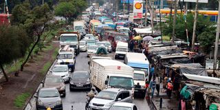
Traffic jam on Jogoo Road, Nairobi after a heavy downpour.
But have they? Nairobi has a problem as it has turned to be the biggest transport hub in the region. Urban transport relies on matatus rather than organised transport, creating a nightmare on roads. After the exit of licensed bus companies that had dominated, matatus took over the void in addition to private vehicles – and now boda bodas.
While matatus conquered the tarmac, half of Nairobi still walked. In Kibera, Mathare, Mukuru and other informal settlements, transport is still on mud or dusty paths, boda bodas and endless waiting.
Nairobi built highways for the wealthy but left the poor on their feet. Roads remained instruments of inequality, mapping privilege by wallet long after colonialism had mapped it by race.
Without a solution to effective urban transport, flyovers and bypasses have done little to ease congestion in Nairobi. As roads expand, more cars fill them. Where a bypass is built, new settlements follow, and traffic clogs it anew.
In contrast, many cities move the bulk of their populations along railwaylines. Nairobi’s promise of metro trains has remained just that – a pledge. The city seems to have forgotten that the railway was once its lifeline, its umbilical cord – a promise of speed, connection and the future.
Somewhere along the road, the promise stalled. It seems Nairobi chose roads over rails – and lost both.
[email protected] @johnkamau1