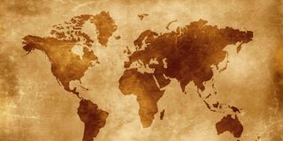
Last Friday, the United Nations General Assembly spent an afternoon debating a map, or more precisely, a projection: the mathematical compromise by which a round Earth is flattened onto a page.
By 164 votes to one, with six abstentions, the world’s governments agreed that schools, ministries and technology companies should show Africa at something closer to its true size rather than the shrunken continent we grew up staring at on classroom walls.
In his paper, “Cartographic Power, Geopolitical Representation and the Politics of International Order”, Dr Gilbert Kimutai, a lecturer in international relations at Maseno University, reads the tally as a price signal: 164 governments found this particular concession cheap, and that cheapness is what the vote actually signifies about Africa’s standing.
Gerardus Mercator drew his world in 1569 to solve a sailor’s problem: how to draw a line on paper that a captain could steer by compass, and he solved it so well that navigators still use it. The cost of preserving those compass bearings is that land appears increasingly enlarged the farther it lies from the equator, making Africa look smaller relative to its northern neighbours. Greenland sits on his map at roughly the size of Africa, which is about 14 times larger. The United States, China and India would fit inside our continent with room to spare, a geographical fact easily missed by a child studying the familiar classroom map.
Kimutai’s argument is that Mercator drew a tool almost five centuries ago and the world quietly promoted it into a truth. No conference was ever convened to decide that a navigator’s aid should hang in every classroom and sit inside the phone in your pocket. It happened by repetition, the form of power that goes unnoticed because it issues no instruction and therefore presents nothing to disobey. Repetition manufactures perception, perception governs behaviour, and behaviour hardens into the decisions that allocate capital, attention and respect. A map teaches what counts as large and what belongs at the edge. Shrinking Africa in the imagination of Africans and the world required no conspiracy. Arno Peters made a version of this argument in the 1970s, tying his equal-area map to the injustices of the newly decolonised South, but the familiar distortions survived the debate.
This year, the same argument arrived carrying the weight of institutions. Africa No Filter and Speak Up Africa had campaigned for the change on the reasonable ground that children raised on a shrunken Africa absorb a shrunken sense of their own continent. The African Union backed the Equal Earth projection, the campaign calling it a matter of “cartographic justice”, and Togo carried the file to New York, where its foreign minister Robert Dussey told the Assembly that “a fair world begins with a fair map”. France co-sponsored the text and announced its own move away from Mercator.
The United States voted no, alone, calling the resolution an ideological agenda that distracted from the “genuine problems of international peace, prosperity or good relations”. Kimutai finds that solitary vote the most revealing detail of the episode, since nobody spends diplomatic capital on a projection unless it has stopped being merely a projection. Where Togo and the African Union heard an overdue correction, Washington heard ideology walking into a chamber built for international cooperation, and underneath the quarrel sat the older question of who decides which grievances count.
Kimutai’s harder argument, and the one I would put to all Africans today, is that the resolution binds nobody, leaves Mercator available for navigation, and asks the international system to surrender nothing of its material power. Africa has spent decades on the requests that carry a price, and those remain pending while a request to be drawn accurately passed in an afternoon. Recognising the continent’s geographical weight is considerably easier than conceding the political and economic influence that Africans have long demanded.
The immediate test sits in the classrooms where the shrunken Africa was taught, since a vote in New York prints no textbooks and the charts hanging this morning are the ones that hung in August. Togo has pledged to replace its school maps by the end of this year, and elsewhere implementation will require budgets, procurement and decisions by education ministries. In Kenya, the question is whether those responsible for what our children learn will translate the diplomatic achievement into teaching materials, or leave another continental commitment waiting for somebody else to act.
The precedent set in that chamber, though, outruns the wall chart. A permanent African presence on the Security Council, fairer debt terms, less restrictive visa regimes and a stronger voice in trade negotiations demand the coordination Togo’s file demonstrated, even if the resistance will be far greater when others have something substantial to surrender. We have spent the better part of five centuries being drawn smaller than we are, and for most of them the distortion was something done to us.
A continent capable of rallying civil society, a Union and 164 votes behind the correction of a picture has demonstrated an ability to organise that its leaders must now bring to harder questions. The map does not remove the obstacles before us, but it weakens the excuse that we are incapable of acting together. What we decline to correct where we have the power to act will become a choice of our own, and a smallness chosen is heavier than a smallness inherited.