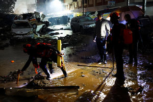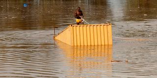
A man uses a rope to pull a container from flood water after heavy rains flooded a quarry within Kamulu area of Nairobi County, Kenya, March 6, 2026.

Weak urban planning, poor coordination of infrastructure, and drainage systems designed for a much smaller population have been cited by experts as key factors linking Nairobi’s growth to recurring floods.
For decades, studies commissioned by both national and county governments warned that rapid urban expansion, encroachment on rivers and wetlands, and uncoordinated development would turn heavy rains into disasters.
As of 4pm on Saturday, the death toll following the floods stood at 25 – 23 from Nairobi –with 11 counties affected and key roads and bridges damaged in multiple counties, according to Public Service and Special Programmes Cabinet Secretary Geoffrey Ruku.
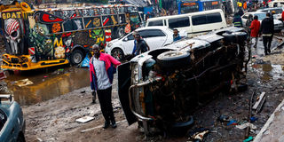
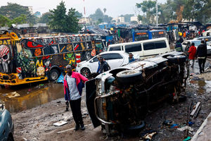
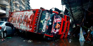
People walk past the wreckages of public transport buses known as matatus, destroyed following heavy rainfall in the Grogan area, popular for automotive workshops and secondhand spare parts, in downtown Nairobi, Kenya, March 7, 2026.
Sunday Nation spoke to experts – the Town and County Planners Association, Institute of Surveyors of Kenya, and the Architectural Association of Kenya – who blamed poor urban planning, overwhelmed drainage systems designed for a significantly smaller population, and concrete jungles that have replaced absorbent soil. Rivers, marshlands, and green spaces that once acted as natural buffers have been encroached upon, turning even moderate rainfall into destructive floods.
Mer Mairura Mwenga, chairman of the Town and County Planners Association, cited rapid urban expansion without corresponding upgrades to infrastructure as the primary culprit.
“Generally, as the city develops, we are destroying or removing natural cover. Trees and forests that used to absorb rainwater are gone, leaving the surface exposed. This is why areas that never used to flood are now under water,” Mr Mwenga said.
According to Mr Mwenga, this misalignment between urban growth and supportive infrastructure has been a long-standing problem.
“Even where drainage exists, maintenance is inconsistent, and piecemeal expansions do not work. For example, along the old roads under the expressway, drainage was damaged or never upgraded, which explains the severe flooding in those areas,” he added.
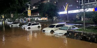
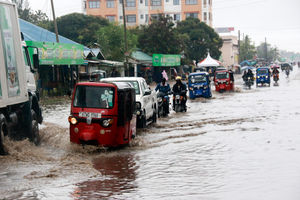
Vehicles remain partially submerged in floodwaters after heavy rainfall caused severe water accumulation on streets in Nairobi, on March 06, 2026.
The planning association’s boss stressed that the shortcomings of Nairobi’s master plan exacerbate the city’s vulnerability to floods.
He said that without a fully integrated approach, infrastructure development such as drainage, roads, and utilities, lags behind rapid urban growth.
“The current master plan, established in 2015, is inadequate. It does not provide a fully integrated approach to infrastructure development, nor does it prioritise the expansion needed to prevent flooding. Planning cannot just stop at the city’s borders; we must consider the wider metro region, because water flows do not respect administrative boundaries,” Mr Mwenga said.
He noted the areas most vulnerable to flooding as low-lying zones along rivers and streams, and places where stormwater naturally accumulates.
He stressed the need for a comprehensive, integrated development plan that synchronises housing, industrial, transport, drainage, and utilities.
“Floodwaters affecting Nairobi may even originate outside the city. So urban planning must consider the broader watershed context. As we develop functional buildings, we must simultaneously expand and maintain supportive infrastructure. Roads, drainage, and power systems must grow with the city,” he said.
Read: Nairobi floods: Death toll rises to 23 as 29 people rescued, 71 vehicles swept away police say
This came even as Democratic Party leader and former Public Service and Special Programmes Cabinet Secretary Justin Muturi insisted that the floods highlight a predictable crisis that occurs year after year with little improvement.
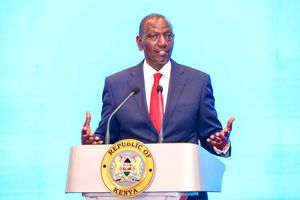
He questioned how Kenya can aim for first-world status under President William Ruto’s “Journey to Singapore” vision while basic infrastructure in the capital continues to fail.
“Nairobi is the capital of Kenya. Its drainage and infrastructure challenges cannot be treated as a routine county issue; they are a national responsibility that should have been addressed long ago. A government that cannot fix drainage in its capital cannot convincingly speak about first-world transformation,” said Mr Muturi.

Members of the Kenya Red Cross search for bodies trapped in the wreckages of vehicles destroyed following heavy rainfall in the Grogan area, popular for automotive workshops and secondhand spare parts in downtown Nairobi, Kenya, March 7, 2026.
Mr Eric Nyadimo, president of the Institute of Surveyors of Kenya, agreed with Mr Mwenga on the trouble of poor drainage, highlighting the critical role of land measurement and mapping in flood management. While topographic maps exist, he noted, they are underutilised and poorly maintained.
He explained that the problem is twofold. First, the drainage networks across Nairobi are often clogged or broken. Second, urban expansion has replaced absorbent ground with concrete, increasing surface runoff.
“We need proper drainage networks to match the water flowing off all this concrete. Most of Nairobi lacks that, and that creates flooding. Many places experiencing floods are not even near rivers. The main issue is the absence or poor maintenance of drainage systems,” he said.
Mr Nyadimo also raised concerns over consultation processes during urban development, noting that surveyors are not always involved in planning approvals.
A matatu lies on top of a private car as a result of heavy rainfall in the Grogan area in downtown Nairobi on March 7, 2026.
Beyond technical issues, he criticised political interference in professional decisions.
“Even where professionals are available to guide planning, they are often sidelined for political reasons. This undermines proper urban management and directly affects residents’ safety,” he said.
Mr George Ndege, president of the Architectural Association of Kenya, said Nairobi’s flooding crisis is not just a natural disaster but a result of years of poor planning, inadequate infrastructure, and uncoordinated urban development.
He gave examples across Nairobi, including Mombasa Road and other major arteries, where roads are often paved and surfaced for vehicles while pavements, storm drains, and other critical infrastructure are ignored.
Mr Ndege also pointed to human interference with the city’s natural landscape as a key factor.
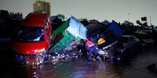
A member of the Kenya Red Cross searches for bodies trapped in the wreckages of vehicles destroyed following heavy rainfall in the Grogan area, popular for automotive workshops and secondhand spare parts in downtown Nairobi, Kenya, March 7, 2026.
“There is this focus on what we are seeing, and whatever we don’t see, it’s like nobody cares. The driveway is where they focus first, but roads have multiple functions. They carry utilities, sewers, stormwater, and communication lines, yet these are neglected. This short-sightedness is what is creating bottlenecks and intensifying flooding. Encroachment into rivers and marshlands, paving over absorbent surfaces, and neglecting green spaces all increase surface runoff. Even areas like Kilimani, which have seen exponential construction of hard surfaces, are now vulnerable to flash floods,” said Mr Ndege.
He stressed that addressing Nairobi’s flooding requires comprehensive planning and multi-functional infrastructure. Roads and parks, for instance, can double as stormwater channels or rain gardens if designed thoughtfully. He warned against temporary fixes, noting that many current interventions are “band-aid solutions” that fail to consider long-term impact.
“We are not learning to improve the future; we are learning to resolve immediate challenges. Historical information—like where marshlands were or where soft soil exists—is crucial to designing for flood resilience,” he said.
He criticised the focus on immediate visible outcomes rather than systemic solutions, and stressed that foresight in urban planning is essential to mitigate flooding in the long term.
Follow our WhatsApp channel for breaking news updates and more stories like this.