Kenya is in the middle of a June-July-August (JJA) season that is not behaving the way it usually does. This period is normally defined by cool, cloudy skies over the central region, including Kiambu, with morning drizzle and fog even in places that see little direct rain. Instead, large parts of the country have spent June and July unusually dry and unusually warm, and forecasters say the trend is likely to carry into a mostly dry August too.
The Kenya Meteorological Service Authority (KMSA) is now tracking an over 80 percent probability of an El Niño event, and officials say the shift is already being felt on the ground, in stalled crops, shrinking water sources and rising maize prices.
"July is generally not a month that receives high amounts of rainfall. However, this year we have experienced prolonged dry spells," said David Koros, Assistant Director of Forecasting Services at KMSA.
"Particularly over the past two months in western Kenya, and the impacts are already being felt through reduced agricultural productivity and growing water scarcity."
The picture is not uniform. According to KMSA data, Kisii recorded an average of 152.0 mm of rainfall, and Busia, Siaya, Vihiga, Kisumu, Kericho, Kisii, Nyamira, Bomet, Homa Bay, Migori, Nyandarua and Nairobi counties saw near-average to above-average rain.
Everywhere else fell short. Marsabit, Garissa, Wajir, Mandera and Makueni counties recorded no rainfall at all during the period.
The first is a cooling air mass moving up from the Southern Hemisphere, the same system that normally produces the cool, overcast mornings at this time of year.
"The cooling air mass coming from the Southern Hemisphere is responsible for the cool and cloudy conditions that we normally experience during this period," Koros explained.
Driver two: El Niño signals building
"There is now more than an 80 per cent probability of an El Niño event," Koros said. "The signals we are tracking are becoming clearer and stronger, and they have the potential to significantly alter Kenya's weather patterns later this year."
KMSA expects El Niño's effects to start emerging around November and December, extending into January 2027.
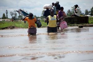
Residents of Ombeyi village in Ahero move to safer ground after heavy El Niño rains in 2023 flooded their homes.
Photo credit: File | Nation Media Group
Driver three: the Indian Ocean Dipole
The third is the Indian Ocean Dipole, or IOD, a shift in sea surface temperatures between the western and eastern Indian Ocean. In a positive IOD phase, waters near the East African coast warm up while waters near Indonesia cool down. That contrast redirects moisture-laden winds toward East Africa, and can bring heavier cloud cover and above-average rainfall to Kenya, Tanzania, Somalia, Ethiopia and Uganda.
"The Indian Ocean Dipole is associated with warming sea surface temperatures over the western Indian Ocean, closer to the East African coastline," Koros said. "We are monitoring its evolution together with El Niño because both climate drivers could significantly influence the country's weather later this year."
What forecasters elsewhere are seeing
The dry spell in Kenya is unfolding against a wider warning about the 2026-2027 El Niño. A new report by Oxford Economics says Africa may be heading into one of its most disruptive climate events in decades. The report cites a Southern Oscillation Index (SOI) reading of -29.1 for July, which it describes as the lowest level in more than 40 years, comparable only to the 1982-1983 El Niño. The Australian Bureau of Meteorology uses the SOI, which tracks pressure differences between Tahiti and Darwin, as a core measure of El Niño strength, with sustained readings below -7 signalling El Niño conditions.
Oxford Economics economist Lyle Begbie warned that a very strong El Niño could bring drought to Southern Africa and parts of the Sahel while triggering flooding elsewhere, putting pressure on food production, water supplies and electricity generation.
"Southern Africa and parts of the Sahel are particularly vulnerable," Begbie said. "While recent bumper harvests in some areas may provide a degree of resilience, the overall economic and humanitarian impacts could be significant."
The report also flags timing as a problem. "These risks come at a time of elevated global energy and fertiliser prices, which will add further pressure to the continent's agricultural sector," Begbie said.
Maize prices already climbing
Back in Kenya, the effects are showing up fastest in the grain basket. Koros said farmers in Trans Nzoia have reported poor maize production after the prolonged dry spells disrupted crop development, and prices have followed.
In Nakuru, a 90-kilogramme bag of maize rose from about Sh3,700 two months ago to between Sh4,500 and Sh4,600 in July. In Narok, the same quantity is now selling for between Sh4,000 and Sh4,600.
Crop losses have been reported across Nakuru, Uasin Gishu, Trans Nzoia, Nandi, West Pokot and Elgeyo Marakwet. In Nakuru's Njoro, Rongai, Mauche and Elburgon areas, some farmers have recorded near-total crop failure. In Trans Mara, particularly Emurua Dikirr and Kilgoris, yields have dropped sharply.
The Kenya Agricultural and Livestock Research Organisation (KALRO) attributes the decline to depressed rainfall combined with pests and diseases, and warns the disruption will hit national maize output this season.
"Most regions have experienced crop failure due to depressed rainfall, while diseases and pests have worsened the situation. This will affect production this season," KALRO said.
Some farmers have uprooted maize before maturity to prepare land for the expected September-October rains. Others have converted failed crops into livestock feed or switched to shorter-season crops such as beans. In Narok, farmers say production has nearly halved, with yields falling from a usual 20 to 27 bags per acre to between 10 and 15.
A withered maize plantation in Uasin Gishu County on August 3, 2026.
Photo credit: Jared Nyataya | Nation Media Group
KMSA's outlook offers little immediate relief. The authority projects near-average to below-average rainfall across much of western Kenya, parts of the Rift Valley and sections of the Coast, with below-average rainfall expected in Turkana, Samburu, and parts of West Pokot, Elgeyo Marakwet and Baringo.
Marsabit, Wajir, Mandera, Isiolo, Garissa, Machakos, Kitui and Makueni are expected to stay largely sunny and dry through the month. Central counties like Kiambu should see their usual cool, cloudy conditions return, while Nairobi is expected to get intermittent rain.
"KMSA is continuously monitoring the strength of El Niño and IOD and their significant impact on the expected weather," Koros said, "and continuously disseminating information to the public at the regional, national and county levels."
He said the priority now is disaster risk planning and helping communities understand what El Niño could mean for them in the coming months.