Every day, dozens of wooden boats, speedboats and fishing vessels crisscross the Indian Ocean channels separating Lamu islands.
Unlike roads, there are no visible traffic lights, lane markings or checkpoints. Navigation largely relies on experience, instinct and split-second judgment by coxswains in the busy waters.
Amidst the routine, marine accidents are common. The latest accident occurred on Saturday, where two people, a mother and her nine-month-old baby, died after two boats collided at Lamu’s Kilindini Channel.
Fourteen other occupants of the two vessels were also injured, two critically, in the 8.43am accident. Kilindini is one of the notorious killer channels in Lamu County and is located between Mkokoni and Kiwayu Island towards the Kenya-Somalia border.
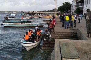
A boat that ferried survivors of the Lamu boat accident arriving at the King Fahd County Referral Hospital Jetty on Saturday, May 9, 2026.
Photo credit: Kalume Kazungu | Nation Media Group
Details emerging from the Saturday accident reveal that almost half of the passengers in the ill-fated boats had no life jackets. Coxswains of both boats were also speeding at the time the head-on collision occurred, according to authorities.
Lamu County Emergency Operation Centre (EOC) Manager Iftakhar Majid noted that despite frequent sensitisation efforts by maritime agencies on the importance of adhering to safety rules while at sea, boat accidents caused by speeding, overloading and lack of life jackets remain a critical safety crisis in Lamu and the wider Coast region.
According to Mr Majid, Lamu County has already recorded six marine-related accidents this year alone, resulting in four deaths.
The number surpasses accidents witnessed between January and December 2025, when five marine accidents left at least 10 people dead.
“It’s unfortunate to see laws being breached. There’s this speeding culture among coxswains in this place. In some scenarios, you’ll find that an accident has occurred and passengers aboard the ill-fated vessels were not wearing life jackets. That’s risky and needs to stop,” said Mr Majid.
Lamu Boat Operators Association Chairman Hassan Awadh cited ignorance as one of the key reasons as to why passengers board overcrowded or unsafe vessels. Mr Awadh said passengers working under tight schedules often pressure coxswains to allow them aboard vessels beyond capacity.
“We also have scenarios where transport options are limited. For instance, passengers headed to far-flung islands like Kiunga, Mkokoni and Kiwayu desperately board overcrowded vessels since those plying the routes are very few. You can imagine a boat going to Kiunga once, twice a day or even after a whole week,” said Mr Awadh.
Boat operators have also cited the lack of clear guidelines of operating in the ocean as a cause for accidents.
“In those channels, we only use common sense to allow others to pass when the tides are low before continuing with our journeys aboard fishing vessels. During high tides, we just study one another’s movement, slow down and pave the way for others by looking at their directions and vice versa,” the chairperson of the Lamu and Coast Beach Management Units Network, Mohamed Somo, says.
Apart from Kilindini, other notorious and dangerous channels in Lamu waters include Mlango wa Tanu in Mkokoni, Mlango wa Ali in Kiwayu, Pezali and Mlango wa Bomani in Kiunga, all in Lamu East Sub-County.
In Lamu West there are Manda Bruno, Mkanda and Shella channels and Mlango wa Kipungani channels. These channels are located in some of the deepest parts of the Indian Ocean in the region.
They are characterised by rough currents accompanied by strong waves. During rainy seasons, they become more dangerous due to reduced visibility, stronger winds and high tides, making navigation difficult.
Athman Bahero, a long-distance shipper plying the Lamu Island-Lamu East route, decried the absence of crucial navigation aids such as buoy markers and lights in most of the channels.
“We need such navigation aids to guide our boats away from dangerous spots, particularly at night or in bad weather,” said Mr Bahero.
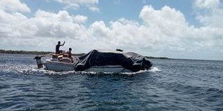
The ill-fated speed boat belonging to the Lamu County government. Four passengers were injured, one critically when the boat hit a seawall hard from the forepart at the Mokowe Customs Jetty in Lamu.
Photo credit: Kalume Kazungu I Nation Media Group.
Ms Roselyne Mapesa, the Kenya Coast Guard Service (KCGS) Director in charge of Enforcement and Emergency Response, said maritime safety is overseen by a multiagency team, including the Kenya Maritime Authority (KMA) and Kenya Ports Authority (KPA).
The KCGS enforces laws and regulations and provides security within territorial waters. Kenyan territorial waters constitute a 12-nautical-mile belt of sea adjacent to the Coast, where the country exercises full sovereignty over the water, seabed and airspace.
Ms Mapesa clarified that an equivalent of road lanes in the ocean exists only within ports, straits or channels. In open waters, vessels use compasses for direction and Very High Frequency (VHF) radios for communication.
These radios are essential for short-range marine communication, operating via line-of-sight with a typical range of 20 to 30 nautical miles. VHF radios are the primary tool for boat-to-boat, ship-to-shore and emergency communication, including Digital Selective Calling (DSC) for instant distress alerts.
She added that speed limits also exist, but only within ports and narrow channels or straits.
“The speed is normally dictated by the port authority of that jurisdiction. But out in the sea, no speed limit unless you’re close to another vessel,” said Ms Mapesa.
On the certification of coxswains in Kenya, she says the documents are issued by Kenya Maritime Authority (KMA) after one undergoes theory and practical training sessions and examinations.
“All this is done in collaboration with approved Maritime Education and Training Institutions such as Bandari Maritime Academy. No one is allowed to operate a boat at sea or in any Kenyan territorial waters without a valid certificate,” said Ms Mapesa.
She further stressed that maritime traffic is a 24-hour affair, noting that at times it peaks during the night and at other times during the day. She warned that it is illegal for sea users or vessel operators to switch off navigation lights at night for any reason.
Ms Mapesa says that under the International Regulations for Preventing Collisions at Sea, vessels are required to display proper navigation lights between sunset and sunrise and during poor visibility.
She says the lights are crucial as they allow other vessels to determine a boat’s position, direction of travel, size and whether it is moving, anchored or restricted in movement.
“Switching the lights off can increase the risk of collision as the vessel is most likely invisible and may even interfere with ongoing search and rescue operations. However, in dangerous waters, operators can switch off the lights for security reasons,” she says.
According to guidelines issued by KMA, it is unsafe and illegal for anyone to operate a vessel on public water without navigation lights at night and during periods of restricted visibility such as fog or heavy rain.
In an effort to improve the safety of seafarers, the Kenya Coast Guard Service, with support from partners including the European Union (EU), has also developed a new app known as Usalama Baharini. It can be used to communicate distress calls, illegal fishing incidents and other emergencies directly to the KCGS operations room, which in turn relays the message to the nearest KCGS station.
Concerning weather alerts and navigation systems to small operators, Ngao Leli, the Director for the Kenya Meteorological Department in Lamu County, says weather updates are regularly circulated to all sea users.
“We advise farmers, fishermen through BMU offices and sailors to always look for updates that we usually circulate through radio stations and social media platforms on the progress of the rains, windy seasons among others. We always do so as a precautionary measure whenever sea users want to venture into the sea for travel, fishing and other activities,” said Mr Leli.
Kenya Red Cross Lamu branch Coordinator Abdulhakim Abdul says the society also works closely with KMA to ensure smooth ocean operations and during rescue missions. He advised water transport users to keep a lookout for fishing nets, reefs and other dhows while moving in the Indian Ocean.
“For safety reasons, one needs to maintain safe speed in channels and avoid restricted naval or port zones,” said Mr Abdul.