Less than three kilometres now separate two of Kenya's most troubled lakes — one freshwater, the other saline — and the government is racing to keep them apart.
For more than a decade, residents of Loboi in Baringo South have watched Lake Bogoria advance towards their homes, farms and businesses, hoping each dry spell would force the waters back.
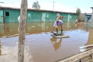
Instead, the lake has continued to expand, swallowing homes, a health centre, grazing fields and thousands of acres of farmland.
Loboi Dispensary in Baringo South on August 26, 2026. It has been engulfed by the flooded Lake Bogoria.
Photo credit: Florah Koech | Nation Media Group
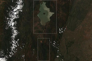
Now the stakes are higher, as authorities fear Lake Bogoria could eventually merge with Lake Baringo, creating an ecological disaster by bringing two radically different ecosystems into direct contact. Lake Baringo is freshwater, while Lake Bogoria is saline and alkaline.
A satellite Image of Lake Baringo and Lake Bogoria.
Photo credit: Esri | Sentinel-2 Land Cover Explorer
Scientists warn that if the two meet, the consequences could extend far beyond the shoreline. The freshwater ecosystem of Lake Baringo could be contaminated by saline water, threatening fish, hippos, crocodiles and the communities that depend on the lake.
The government has responded with an ambitious engineering plan that includes building a dyke to hold back Lake Bogoria, controlling the rivers that feed it, and constructing a major drainage system to move excess water from Lake Baringo away from vulnerable communities.
The latest plan includes a five-kilometre dyke at Sandai to prevent the lakes from merging, a medium-sized dam across the Waseges River to trap excess runoff before it reaches Lake Bogoria, and a six-kilometre evacuation tunnel linked to an approximately 40-kilometre canal to move excess water from Lake Baringo towards Chemolingot and eventually the Suguta Valley.
The intervention marks a shift from years of emergency response and adaptation towards large-scale engineering aimed at controlling the water before the crisis becomes irreversible.
A multi-agency team comprising officials from the State Department for Environment and Climate Change, the Kenya Defence Forces (KDF), the German Development Agency (GIZ) and the Kenya Red Cross has been assessing the terrain, water availability, flood risks and infrastructure required.
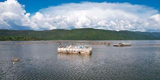
Noosukro Primary School on the shores of Lake Baringo. It has been swallowed by the lake's waters.
Photo credit: Florah Koech | Nation Media Group
For Baringo Governor Benjamin Cheboi, the scale of the disaster has overwhelmed the county's ability to respond alone.
"This flooding is so massive that as a county government we cannot manage it on our own. That is why we have sought support from the national government and other partners," said Governor Cheboi.
Lake Bogoria expanding significantly
Residents say Lake Bogoria began expanding significantly around 2010 before accelerating in 2013, forcing villages to retreat as the water advanced.
Mr Bismark Kibet said more than six villages, including Chepng'erechi and Kaprong'uno, have been affected.
"Sometimes the water reduces slightly when rainfall decreases, but once heavy rains return, the lake expands again. That has been the pattern for years," said Mr Kibet.
"We thought it would recede, but it hasn't. It has swallowed homes, grazing land, farms and even our dispensary," he said.
Thousands of acres of farmland and grazing land have been lost, while much of the flooded land has become too saline to support farming even if the water eventually recedes. At one point, residents struggled to find land on which to bury their dead.
For families still living between the two expanding lakes, the proposed dyke is more than an engineering project — it represents a physical barrier between their communities and the advancing waters.
But the threat extends beyond homes and farmland. Lake Bogoria Senior Warden James Kimaru said the lake has expanded from about 34 square kilometres in 2013 to roughly 45 square kilometres presently.
As the waters advanced, roads and other infrastructure inside the reserve had to be relocated, while submerged geysers and flamingo-viewing areas have dealt a heavy blow to tourism. Mr Kimaru estimates that the reserve loses more than Sh100 million annually because of damaged roads and flooded attractions.
He warned that water from the northern side of Lake Bogoria is already draining towards Lake Baringo.
"If the lakes merge, the ecological consequences could be severe," he said.
Spatial environmental planner and geologist Prof Simon Onywere believes the two lakes are closer than ever. According to Prof Onywere, the distance separating them has shrunk from more than 20 kilometres historically, to about seven kilometres in 2020, and now to less than three kilometres.
"The merging of the two lakes is imminent — it is just a matter of time," he warned, adding that his concern is not merely geographical.
Lake Baringo is a freshwater ecosystem, while Lake Bogoria is saline and alkaline. Scientists fear that contact between the two could disrupt Lake Baringo's ecological balance and threaten species and communities that depend on the freshwater lake.
Prof Onywere said heavy inflows from River Waseges continue to push water into Lake Bogoria, increasing the likelihood of saline water spilling towards Lake Baringo.
"If this continues, Lake Baringo could gradually become alkaline, threatening fish, hippos, crocodiles and the communities that depend on the freshwater lake," he said.
He added that deeper waters in Lake Bogoria have already affected flamingo populations, because the birds can no longer easily feed in the shallow areas on which they depend.
Flamingoes in Lake Bogia in 2024. The number of flamingos in the lake has declined from millions to about 400,000.
Photo credit: File
The government's response is effectively a two-front battle. At Lake Bogoria, the strategy is to prevent further expansion towards Lake Baringo by constructing the Sandai dyke and controlling runoff through the Waseges River. At Lake Baringo, the plan is to remove excess water rather than simply contain it.
The proposed tunnel-and-canal system is intended to evacuate excess water from Lake Baringo towards Chemolingot before it flows into the Suguta Valley. In the longer term, the diverted water could be directed into the Kerio River to increase inflows into the proposed Lowaat Dam.
The government also wants to turn the excess water into an economic resource through irrigation. An earlier proposal envisaged channelling water towards Tiaty to irrigate about 1,000 hectares. The latest government announcement, however, says the wider programme could support irrigation of at least 100,000 acres in Baringo, and potentially neighbouring Turkana, under a private investment model.
The scale of the latest proposal underscores the government's attempt to recast the crisis from a disaster-management problem into a water and economic-development project.
But Lake Baringo itself has been undergoing a dramatic transformation. Senior Warden Jackson Komen said its surface area has expanded from about 178 square kilometres to more than 260 square kilometres over the years.
The rising waters have affected schools, homes, businesses and tourism facilities around Salabani and other lakeside settlements. Soi Safari Lodge, Roberts Camp, Lake Breeze and Block Hotel are among the tourism facilities that have suffered major losses after cottages and guest rooms were engulfed, with the human cost equally severe.
Loboi Chief Festus Kiptishia said more than 250 households have already been displaced, three villages have disappeared, and more than 2,500 acres of farmland are underwater.
"We appeal to the government to hasten this process before the heavy rains begin. The lake has not receded despite the dry spell, and people fear it will rise even further," he said.
Kenya Defence Forces Major General William Kamairo said the government wanted a permanent solution rather than another temporary response.
"We do not want to do a quick fix to this perennial problem. We want to provide a lasting solution after listening to the affected communities," he said.
Ms Pacifica Ogola of the Directorate of Climate Change said authorities were preparing for possible extreme weather linked to the forecast El Niño rains.
"We have seen the impact these rising lakes have had since 2010. We want to develop a lasting solution before more families lose their homes and livelihoods," said Ms Ogola.
She said the government would first establish the number of affected households before developing a comprehensive response involving multiple ministries and the military.
Environmental expert Raphael Kimosop attributes the crisis to prolonged heavy rainfall combined with poor upstream land management, which has accelerated soil erosion and increased the amount of sediment entering the lakes.
"The lake began rising around 2011. Water levels briefly receded in 2022 and 2023, before increasing again after heavy rains," said Mr Kimosop.