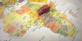
Last week’s UN resolution to recognize the true size of countries worldwide has generated keen interest. Understandably, enthusiasm has brimmed in Africa, the region that benefits most from the bulge in its true size when visual cartographic accuracy is affirmed.
Entitled “Correct the map: rebalancing global cartographic representation and promoting equitable representation of the world’s regions, particularly Africa”, it has been abbreviated simply as “Correct the Map”. Three agential words that should give a dose of optimism in the coming months, if not years!
Togo sponsored the motion with support from France and the African Group at the United Nations. For starters, small-sized Togo has won accolades for championing a large-sized agenda. Togo’s expert navigation of the motion bestows on it an image boost on the global map.
France, Togo’s former colonial ruler, which has suffered a decolonial berating in Africa in recent times, likely co-sponsored the motion on both ethical and fence-mending grounds. On this resolution, the former colonial power is on the right side of history.
The vote was decisive. 164 countries in support, six abstentions (Estonia, Georgia, Lithuania, Moldova, Serbia, and Ukraine), and one against (United States). It is a curiosity as to why the Eastern European countries chose to fence-sit. Strikingly, the five former soviet republics (only Serbia is not in this category) elected to adopt an ambivalent posture.
The US opposed the motion on the grounds of the “ideological agenda they promote” and for the UN ostensibly losing credibility by veering off its core mandate of peace and security.
It is not too far-fetched to surmise that Africans are a little bit buoyed thanks to their habitation on a mass of land that now looks bigger on maps on paper, even if neither an inch of land nor a dollar in the pocket has been added!
The deeper significance can take both symbolic and pragmatic dimensions. Notably, the Togolese Foreign Minister, Robert Dussey, framed the motion as “a fair world begins with a fair map”. This implies that there is lots of unfinished business regarding global inequality, beyond the face value of a cartographical change.
Wider and futuristic analysis, however, shifts the symbolic dimension toward pragmatism. It reveals the important ramifications for Africa and its place on the world map. For instance, the Mercator map, used primarily for navigation, was instrumental in the transatlantic trade. If the Mercator map greatly aided navigation, then we can also say it made ferrying Africans to the labour markets of the Americas and Europe more efficient, with devastating consequences for the continent. Take this angle, and the Mercator projection was a lethal tool of slavery! Yet, the Mercator map has served many positive aspects, including facilitating African maritime trade, especially in the post-independence era.
“Correct the Map” is the second time this year that the UN has voted in the affirmative on a major Africa-sponsored motion. The first one was the Ghana-sponsored resolution declaring the transatlantic slave trade the gravest crime against humanity, which was passed in March. In that vote, 123 countries voted in favour, 52 abstained, and three - Argentina, Israel, and the United States – opposed. Interestingly, Togo, a small country on the African map, is a neighbour of Ghana, one of the medium-sized countries.
The two resolutions give hope to Africa and Africans regarding other UN-managed global governance issues impacting the continent.
From symbolism to pragmatism
Several world map projection versions are being touted as replacements for the Mercator projection map. Togo has adopted the Equal Earth projection drawn in 2018. France has opted for the Eckert IV projection, first developed in 1906. The Robinson projection is also relatively popular, among at least 8 other projections. Still, some countries may choose to stick with the Mercator projection.
It also remains to be seen if international organizations led by the UN itself will start using new maps. Certainly, African international organizations, starting with the African Union and the regional economic communities, should be at the forefront of endorsing and using one of the visually acceptable maps.
It is likely that different countries will adopt different maps, posing challenges for standards and uniformity. It implies that map users around the world will see different maps whether in formal or informal settings. Further guidance from the United Nations is necessary. Africa should, however, have no problem switching to a new map projection version. Togo should work with the African Union to recommend the most preferable version.
Some commentators have argued that pursuing the “Correct the Map” agenda is wrongheaded because this is not a priority for a continent beset by impoverishment, pestilence, and conflict. Pessimists who argue that the Mercator map is not the biggest problem that Africa faces conveniently allow amnesia about Togo’s framing of the UN motion. It stated that the motion was not meant to dismiss the Mercator projection, but to promote the Equal Earth projection, which, well, projects a more accurate representation of the continent’s size. Secondly, the Equal Earth projection serves the same purpose as the Mercator map without distorting the sizes of countries and regions.
Dismissing the symbolism of the map correction as economically valueless skates over the kind of mindset shift that can propel economic renewal. Although the Mercator projection was meant to ease navigation, it morphed into a representation of Africa as smaller than its true size. Thus, one can’t delink the navigational origins of the map, the continued use for navigation, and the representational eventualities. The representation of Africa is a big deal. The artificially “small” map size that has been used is not materially different from the characterization of the continent as the dark continent, a notion created via the 1878 biography of Welsh-American explorer Henry Morton Stanley, Through the Dark Continent.
As framed, the “correct the map” resolution does not compel countries to act in favour of more visually representative maps. Yet, the symbolic weight of a UN resolution can be a springboard for professionals, businesses, and academics in many fields. For instance, cartographers and geographers, as academic and professional fields, should weigh the resolution’s implications in classrooms, drawing rooms, and in aerial, maritime, and terrestrial spaces.
Countries and companies in the satellite sector may want to investigate how the shift in map usage influences their peering over planet Earth from outer space. Geologists may be motivated to go beyond the new African map to map African minerals and natural resources. Tech companies in geospatial and geographic information systems may be curious enough to try to figure out what has been missed due to the use of the sixteenth-century map. In a nutshell, just about any aspect of life can be linked back to this single resolution.
Togo has indicated that a meeting is in the offing to discuss the next steps after the “Correct the Map” triumph. A mechanism to include African companies, professionals, and academics working in mapping or with maps should be included, given the numerous opportunities that the implementation of the resolution portends. Indeed, assembling experts from multiple fields stands the best chance of implementing such an open-ended global resolution.
The author is a media and geopolitics scholar at the University of the Witwatersrand, South Africa: [email protected]