Antony Mwithaga was born and raised in Nakuru and has lived there for the past 55 years. He says some of the jacaranda trees along Oginga Odinga Street were planted in the 1950s.
For decades, the trees have stood as silent witnesses to the city’s transformation from a small urban centre into one of the fastest-growing cities. Their purple blossoms and towering canopies have been part of the city’s identity and provided shade.
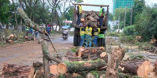
In recent weeks, some of the mature trees have been felled to pave the way for the dualling of a five-kilometre stretch of Oginga Odinga Street, the longest in the city, stretching from Industrial Area to Free Area, which feeds into the Nakuru-Nairobi Highway.
The project by the Kenya Urban Roads Authority (Kura) is aimed at easing congestion and accommodating the city’s growing traffic. For some residents, the trees represent much more than roadside vegetation. They are the city’s green heritage.
Mwithaga remembered when Nakuru had a reputation as one of the cleanest towns in East Africa. He says the trees played an important part in that.
According to Mwithaga, urban development should be balanced with environmental conservation, and mature trees should not be cut whenever infrastructure projects are undertaken.
He questioned why the decision was passed without public participation, saying residents could have been given an opportunity to air their suggestions. Public participation, he says, would also have involved civil engineers who could have offered an alternative design for the road.
“As residents, we are not objecting to any sort of development, whether it is expansion of the road, we want the assurance that the trees will be replanted because that has been synonymous with our city. There was no public participation and yet it is in the Constitution that is the work of the city manager to alert people that something is coming up to our city so that people can give out suggestions,” he said.
Reuben Makori, a trader along Oginga Odinga Street, said the trees provided shade for traders displaying their goods along the stretch. He says the felled trees were left lying on the footpath, inconveniencing pedestrians. Traders had been warned that the project could affect their business, leaving them uncertain about their future.
“We were told that the expansion of the road might affect our business. It is a wait-and-see situation. They should allow us to continue with our business because this is where we depend on for our livelihood,” he said.
In an earlier interview with the Nation, Kura South Rift Regional Director John Orwa confirmed that the project will run from the overpass near Nyahururu Road to the Westside roundabout, creating a four-lane carriageway. The upgraded road will feature drainage channels on both sides, pedestrian walkways, and a dual carriageway with two lanes in each direction separated by a central median.
He said the project requires a 30-metre road reserve, compared with the current corridor, which measures slightly above 15 metres, and that traders within 30 metres will be affected. The Sh850 million road is being designed to accommodate all categories of vehicles and will not be restricted to private motorists.
Eng Orwa said the project will also incorporate improved drainage to help address flooding in low-lying areas along the corridor.
“As far as the flooding is concerned, it is a big issue for those who are downstream because all the water from upstream affects them. We look forward to trying to address that using the drainage facilities that we will provide. The project is expected to be completed within 24 months,” he said.
John Cheboi, Kura’s communications officer, said Oginga Odinga is one of the most congested roads in Nakuru and that the expansion will decongest it. He says the dualling of the Rironi-Mau Summit Highway will bring more traffic, so dualling this stretch will help divert traffic towards the city.
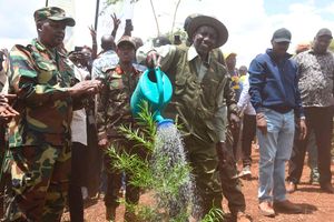
“Along that road we have beautiful jacaranda and other trees which were planted a long time ago, but now we are expanding the road and dualling it; the trees have to give way. We have about 200 trees that have to give way. We have had meetings with stakeholders and informed them that we will cut trees, but the law demands we plant more when we finish the road. As soon as the road is done, we will plant new trees,” he said.
Jackson Raini, an environmental scientist with the Flamingo Conservation Network, said no public participation was held before the trees were cut. He faulted Kura for not conducting it before cutting trees along Oginga Odinga and Tom Mboya streets, and says the same happened along the Rironi-Mau Summit corridor, where the Kenya National
Following up with the National Environmental Management Authority (Nema), he noted that the authority said it had not received any environmental and social impact assessment report. He also says residents have not seen the report, or any approval from Nema giving the green light for the project.
“We visited the Nema offices, and the response we got was that they had not received the environmental and social impact assessment report on the Oginga Odinga Road expansion project. That means that any clear felling of trees along this corridor is illegal. Secondly, public participation is enshrined in our Constitution; that means the people ought to be consulted when the trees are being cut,” he said.
Raini said Nakuru has seen a lot of development. The county has expanded from about 78 square kilometres to the current 198 square kilometres, and the population has grown from 100,000 in the 1980s to about 600,000. Within the city, he said, green spaces are shrinking. Menengai Forest has seen development related to geothermal exploration and drilling, as well as serious forest fires, while at Lake Nakuru National Park the green spaces are shrinking because of rising water levels. In the Eastern Mau, he said, forest cover has shrunk from 40 per cent in the 1980s to about seven per cent.
He explained that the felling contradicts President William Ruto’s directive, issued four years ago, to plant 15 billion trees, and impedes the country’s goal of 30 per cent national tree cover by 2032.
“We are well below the 10 per cent tree cover and forest cover in our country. We must walk the talk. What we are seeing is a clear felling of trees across the country from Kakamega, Aberdare, Mau, the Ngong, Karura, and Imenti forests where they are currently clearing trees for golf courses and airstrips,” he said.
Raini added that the trees played an important role in the dry season, when the city has major dust problems, and helped filter air as the population and the number of motor vehicles grow. He said with El Nino expected, sediments from the city will be washed downstream to low-lying settlements, exposing estates to flooding.
“The timing is bad, and it was not consultative because there was no engagement of local communities and various expert groups, including civil society. Engineers from Kura could have designed the roads in a manner that integrated the trees. We have not documented the number of trees that will be cut in the main highway project and we have not seen a clear mitigation plan on how the trees will be replaced,” he said.
In September, the county government mapped over 70 flood-risk zones, with Nakuru Town East and Nakuru Town West carrying the heaviest concentration at 15 sites each. Deputy County Secretary Newton Mwaura said a multi-departmental response team, working with the national government, has started clearing drainages and culverts. Rescue and evacuation points have been set up, and three hospitals, including Nakuru Referral and Teaching Hospital, Naivasha Level 4 Hospital, and Njoro Sub-County Hospital, have been earmarked for emergency cases, with 22 ambulances and three fire trucks on standby.
A widely cited benchmark holds that sustainable cities should keep at least 30 per cent tree canopy cover in every neighbourhood. It is part of the “3-30-300 rule”: three trees visible from every home, 30 per cent canopy cover in every neighbourhood, and no more than 300 metres to a high-quality green public space.
Researchers have put Nairobi’s tree cover at roughly 13.74 per cent. The city has set a goal of 30 per cent by 2032, including planting one million native urban trees. In Nakuru, baseline forest and tree cover is estimated at 9.2 per cent, against a national average of 12.13 per cent.
Nakuru County has already seen what happens when the land cannot hold the rain. In April 2024, a blocked culvert beneath a railway embankment triggered a catastrophic failure near Mai Mahiu, killing at least 61 people, injuring 109, and leaving 37 missing as of May 7. The flood was traced to the upper Kijabe Hills, where vegetation had been stripped and farmland scarred by gullies in villages including Kamuchira, Jerusalem, and Githioro.
Around the same time, more than 100 families in Kaptembwa, Nakuru Town West, fled their homes after flash floods caused deep gullies, mudslides, and sinkholes, with residents blaming an incomplete drainage system. Maize farms in Salgaa, Rongai, were submerged. By late 2025, the threat had shifted to Lake Naivasha, whose waters had travelled up to 1.5 kilometres inland into Kihoto village in November, submerging homes, churches, and even a police station.
Mwithaga said residents want the same assurance that accompanied previous road projects, where trees were replaced after being removed to create space for infrastructure.
“As residents, we are not objecting to any sort of development, whether it is expansion of the road. We want the assurance that the trees will be replanted because that has been synonymous with our city,” he said.