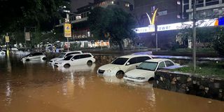
Vehicles remain partially submerged in floodwaters after heavy rainfall caused severe water accumulation on streets in Nairobi, on March 06, 2026.

Nairobi did not become a flood victim with the ongoing rains. It was born one.
The earliest descriptions of Nairobi were never flattering. Railway engineer Richard Owen Preston, who knew Nairobi as Mile 326, described the site as 'a bleak, swampy stretch of soppy landscape, windswept, devoid of human habitation of any sort, the resort of thousands of wild animals of every species.'
Writer Elspeth Huxley later wrote of frogs whose chorus swallowed the little township each evening. The blue-gum trees introduced in the early years by Commissioner John Ainsworth were not merely ornamental. They were part of an effort to drain a place that had no business pretending to be dry. Those trees stood as living admission that Nairobi had been planted on wet ground.

A bridge over the Nairobi River is swept away as floodwaters encroach on land in the Grogan area of downtown Nairobi on Sunday, March 8, 2026. Heavy rainfall on March 6 destroyed vehicles and damaged businesses in the district, which is widely known for automotive workshops and second-hand spare parts.
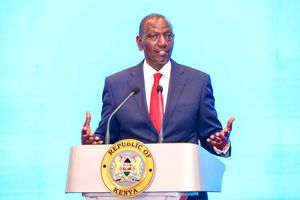
As Governor Johnson Sakaja faces mounting criticism over flooded roads and swelling rivers, one fact remains: whatever his shortcomings, he inherited a crisis far older than his administration. Nairobi’s flooding problem was generations in the making and will likely take decades to reverse.
The city’s pioneer administrator, John Ainsworth, planted blue gum trees and tried to tame the marshes. Nairobi was so notoriously muddy in its early years that it drew international attention in 1909, when former US president Theodore Roosevelt is said to have become stuck in the mire as he set off on a game safari. If the city today suffers from inadequate infrastructure, that failure cannot be understood apart from a long history of official neglect. Sakaja happens to be the gatekeeper of that continuity.
For long before surveyors drew neat boundaries on maps, before roads were named and neighbourhoods dignified with titles, the site that became Nairobi had already declared its nature. In the rains, it was a floodplain, in drought, a hard, windswept swamp. Railway men saw a convenient flat stretch where wagons could turn, and stores could be erected before the climb to the highlands. Nature saw something else entirely: a basin for water, reeds, papyrus and marsh life.
That was the first truth, and it is the truth Nairobi has been trying to outbuild ever since.
Yet the town, as a result of poor planning, corruption, lack of foresight, has remained trapped by its original mistake. From early on, there were suggestions that it should be moved to Kikuyu rather than back to Machakos, the early interior capital of Imperial British East Africa company.
There were warnings that the settlement was rising in the wrong place. Medical and sanitary alarms were raised as Nairobi struggled with rats, plague and chronic drainage failures during its pioneer days. Better-drained ground lay only a short distance away.
But within the Railway administration, led by George Whitehouse, hesitation triumphed over foresight. Some argued that no true city had ever grown out of a railway depot, even though Nairobi itself had been chosen for little more than railway convenience and administrative ease.
When Winston Churchill, then a secretary of state, visited the new town in 1907, he saw the problem clearly enough.

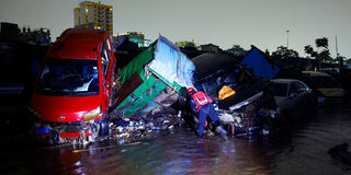
A matatu lies on top of a private car as a result of heavy rainfall in the Grogan area in downtown Nairobi on March 7, 2026.
In his book My African Journey, Churchill wrote of Nairobi. "Originally chosen as a convenient place for assembling the extensive depots and shops necessary to the construction and maintenance of the railway, it enjoys no advantages as a residential site. The ground on which the town is built is low and swampy. The supply of water is indifferent, and the situation is generally unhealthy. A mile farther on, however, upon the rising ground, a finer position could have been found, and this quarter is already being occupied sparsely by Government buildings, hospitals, and barracks. It is now too late to change, and thus, lack of foresight and of a comprehensive view leaves its permanent imprint upon the countenance of a new country."
Thus, although Churchill admitted that Nairobi was low-lying, swampy, unhealthy and poorly supplied with water, and recognised that a finer site could have been chosen on nearby higher ground, his fatal sentence — “it was too late to change” — sealed the city’s fate in the grip of its geology. Like the administrators who came after him, he diagnosed the disease but declined the surgery. He saw the mistake, called it “lack of foresight”, and then permitted that failure of foresight to harden into policy.
That failure did not end with Churchill. It merely changed hands.
Read:Shame of Kenya’s Sh35bn spend on flood control in four years as fresh rains expose poor planning
What began as a colonial blunder evolved into a civic habit. Every generation inherited the warning and ignored it in its own fashion. Nairobi’s planning history is, in many ways, the history of a city that has kept postponing its reckoning with water. At the moment, Governor Sakaja may be blamed for failing to unblock sewers as John Gakuo once did, and for allowing construction chaos to spiral. But the deeper truth is that Nairobi’s mess did not begin with him. It is the product of decades of neglect, weak planning, and a political culture that has repeatedly chosen delay over reform.
The first schemes for the railway town concerned order, boundaries and expansion, not the deeper hydrology of the basin. The 1927 Nairobi plan was commissioned in 1926 by the colonial government and was planned by Eric Dutton, drawn by F. Walton James, and approved by the Governor in December 1927. While the report spoke of drainage and draining swamps, its true energy lay in accommodating urban spread. It is claimed that the plan expanded the city without restoring the natural systems that had governed the land before surveyors arrived. Swamps were treated as inconveniences to be subdued, not as ecological signals to be respected.
During Governor Philip Mitchel’s rule, South African planners were brought to draft Nairobi’s 1948 master plan, a blueprint meant to shape the city over 25 years. But the plan did more than organise growth. It laid the foundation for a racialised city, introducing modern zoning, separating residential areas by class and race, and assigning land uses in ways that entrenched inequality.
The effects were immediate and lasting. Poor residents, most of them Africans, were pushed to the city’s most vulnerable lands and denied basic services. At the same time, Nairobi’s rivers were no longer treated as living ecosystems but as technical problems to be controlled. They were turned into drainage channels, a shift that effectively formalised the long-term pollution of the Nairobi River and Ngong Rivers.
Town planning collapsed
The push for industrialisation south of the railway station, in what is now the Industrial Area, added another layer of damage. Expanding factories and paved surfaces reduced the land’s ability to absorb water. As riparian zones shrank, natural infiltration areas disappeared. In the name of orderly development, Nairobi’s hydrology was permanently reshaped.
At independence in 1963, Jomo Kenyatta’s government inherited a city already straining under the pressure of rural-urban migration. Despite Kenyatta’s call to turudi mashambani—return to the rural areas—Nairobi’s population kept rising sharply growing by about 48.6 per cent between 1963 and 1969, by 62.5 per cent between 1969 and 1979, and by 60 per cent between 1979 and 1989.
While the 1973 growth strategy, prepared during Mayor Margaret Kenyatta’s tenure, recognised the pressures of urban expansion it offered little by way of hard safeguards for rivers, riparian reserves or stormwater management. Critics say that it was a plan for a growing city, and not for a city that remembered where its water wanted to go. As a result, the drainage for an extending city remained poor or nonexistent.
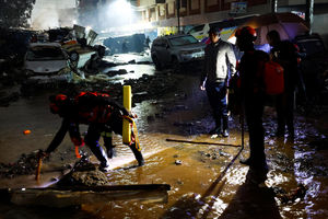
A member of the Kenya Red Cross searches for bodies trapped in the wreckages of vehicles destroyed following heavy rainfall in the Grogan area, popular for automotive workshops and secondhand spare parts in downtown Nairobi, Kenya, March 7, 2026.
As corruption seeped into city management and town planning collapsed, settlements arose without proper drainage. New estates and slums, built without the necessary sewerage infrastructure, finally stripped away any pretence of Nairobi as a modern city. Planned estates, such as Buru Buru and Umoja collapsed as city fathers watched. In the chaos, drainage was the first casualty.
As the population grew, former ranches in the outskirts of Nairobi, starting with Embakasi and Dandora became urban jungles in the 1980s. The Nairobi Integrated Urban Development Plan of 2014 did not cure this problem and only acknowledged drainage and river restoration in broad language.
In upper Nairobi, glass towers and concrete apartments rose in places once occupied by single dwellings and gardens. Kilimani and Kileleshwa were the first to go and now pressure is on Parklands – all with approval by a County government t that has hardly expanded the sewer system. With that, the soil that once absorbed rainfall was sealed; runoff was accelerated; and water that used to soak quietly into the earth now rushed downhill with purpose.
While Westlands, Kilimani, Parklands, Lavington and other upper areas may congratulate themselves on redevelopment, the runoff generated here does not remain there. It moves downward, toward Mukuru, Mathare, Embakasi, Kamukunji and every constricted channel that policy forgot. More so, the rivers are too narrow to contain the runoff and as a result the flood wades beyond the riparian areas as witnessed in Kirinyaga Road.
The early railway engineers, for all the violence and arrogance of colonial infrastructure, at least learned from washaways. When floods destroyed bridges or undermined embankments, they enlarged culverts, strengthened works and revised designs. Nature exposed an error; engineering responded. Today we often do the opposite. Nature exposes the weakness and politics produces a press conference.
The story of Nairobi is best understood by saying: When the upper Nairobi becomes more paved, lower Nairobi receives the burden. When approvals are issued for higher plot ratios and greater ground coverage without corresponding stormwater infrastructure, someone downstream pays the price. When rivers are narrowed by encroachment in one ward and drains go unmaintained in another, floodwater assembles these failures into a single event.
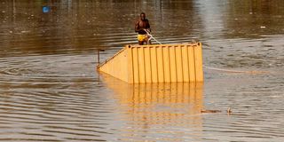
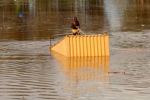
A man uses a rope to pull a container from flood water after heavy rains flooded a quarry within Kamulu area of Nairobi County, Kenya, March 6, 2026.
That is why the present crisis cannot be blamed on rain alone. Rain is the occasion, not the cause. The cause is historical amnesia joined to policy laziness and political cowardice.
From Ainsworth to Sakaja, the story of Nairobi is also the story of a city at war with its own terrain. It was founded on a wet plain, then remade through amnesia, as if swamps could be forgotten, rivers contained and floodplains wished away. Politicians offered roads, housing and growth, while avoiding the less glamorous task of defending waterways from settlement, speculation and lawlessness.
Each time the rains return, the damage is explained away as misfortune, even as an act of God. But Nairobi’s floods are not heavenly accidents. They are the judgment of history on decades of human choices. The water does not arrive to surprise the city; it arrives to remind it of everything it chose to ignore.
Follow our WhatsApp channel for breaking news updates and more stories like this.