Key stakeholders in the transport sector are on the spot due to accidents that keep occurring in known black spots with no efforts to make improvements.
Despite years of road safety audits, public warnings, and continuous promises of stricter enforcement, the death toll on key transit routes continues to rise.
The recent loss of 41 lives in major crashes along the Nairobi-Mombasa Highway, occurring only weeks apart, has renewed urgent questions about why known hazardous sections – vividly mapped and documented by authorities – remain active death traps.
The most recent tragedy occurred at the Koriomat area on the Nakuru-Eldoret Highway on Friday night where six people died following a crash that involved three vehicles.
Before that, a major crash happened in the Kanga area on the Nairobi-Mombasa Highway last weekend, where a catastrophic collision claimed 24 lives.
This disaster followed closely on the heels of a multi-vehicle crash near Salama on the same highway, which claimed 17 lives as passengers were traveling toward Nakuru.
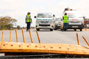
A police officer and an official from the National Transport and Safety Authority inspect vehicles at Salgaa area along the Nakuru-Eldoret Highway on December 4, 2025.
Photo credit: Boniface Mwangi | Nation Media Group
The incidents point to an entrenched systemic crisis. Faced with escalating highway fatalities, NTSA’s Director of Road Safety, Dr Andrew Kiplagat, has made a direct appeal to elevate the country's road safety crisis into a formal national disaster declaration.
With that declaration, he says, the government can mobilise emergency funding from the Treasury, and force a unified response across competitive government entities.
Dr Kiplagat, in an interview with NTV last week, emphasised that road safety is not just a transport issue; it is a national development and security priority.
“Road safety is not just a transport issue; it is a national development and security priority. We need everybody on the table. We cannot act alone as NTSA. We need everyone as what is happening will continue and we cannot allow it to continue,” Dr Kipalgat told NTV .
If it frames road safety as a national security threat, Dr Kiplagat argued, the State can properly coordinate interventions across various regulatory arms.
The authority estimates that roughly 20,000 road crashes occur annually within Kenya, cumulatively claiming more than 5,000 lives. Data from the Kenya National Bureau of Statistics (KNBS) Economic Survey 2026 confirms this upward trajectory, noting that reported road traffic fatalities climbed to 5,009 in 2025, up from 4,748 recorded in 2024.
By October 4, the NTSA had already logged 3,995 deaths, representing a grim national average of roughly 14 fatalities every single day. A breakdown of these numbers reveals a stark vulnerability among non-motorised and exposed road users, with pedestrians accounting for 1,490 deaths, motorcyclists at 1,061 deaths, passengers at 662 deaths, and drivers at 352 deaths.
While driver behaviour is frequently blamed for these outcomes, the NTSA emphasises that the spatial concentration of these crashes points to a more predictable, localised danger – the black spots.
NTSA has formally identified more than 270 road crash black spots across the country. Crucially, a staggering 199 of these black spots sit clustered along the Mombasa-Malaba Northern Corridor, which is the economic artery connecting East Africa’s primary seaport to the Ugandan border and the wider continental interior.
“Out of the road safety audits that the authority does, all the blackspots right from Mombasa to Malaba are known. Ideally, we should have separation of traffic, at least those flowing in one direction,” said Dr Kipalgat.
The mapping of these 199 hazardous zones dates back to a joint multi-agency exercise conducted in 2017 involving the NTSA, the Kenya National Highways Authority (Kenha), the Kenya Urban Roads Authority (Kura), the traffic police, and road safety civil groups.
To better prioritise engineering investments, a subsequent detailed survey was executed by the Northern Corridor Transit and Transport Coordination Authority (NCTTCA) alongside Kenha and the Kenya Transporters Association. This study isolated 10 high-priority sites based on a rigorous combination of historical crash frequency, collision severity, and the Equivalent Property Damage Only index.
The historical baseline data gathered from these 10 priority locations illustrates the immense scale of the problem. The Mukinya-Migaa-Sobea-Salgaa-Sachangwan stretch recorded the highest numbers with 152 crashes.
NTSA has made a direct appeal to elevate the country's road safety crisis into a formal national disaster declaration.
Photo credit: Pool
This was closely followed by the Gitaru-Rungiri section with 117 crashes, the Kibarani-Makupa Causeway with 107 crashes, and the Molem-Namba Okana-Nyamasaria-Kasagam corridor with 100 crashes. Further down the registry, the Emali-Pipeline segment logged 89 crashes, Bonje recorded 85, Maji ya Chumvi had 75, the Konza-Malili section saw 69, the Ngokomi-Kalimbini stretch recorded 68, and the Mlolongo segment registered 65 crashes.
A critical finding from the engineering audits is that simple crash volume does not fully capture the localised risk to human life. When evaluating sections based on crash density – the number of incidents per kilometre – the hierarchy of danger changes radically.
For example, the Ngokomi-Kalimbini section recorded 68 crashes along a tiny stretch of just 0.9 kilometres. This condenses down to an astonishing 75.56 crashes per kilometre, making it the highest concentrated risk zone among all ten priority sites audited. Similarly, the Gitaru-Rungiri section experienced 117 crashes across 2.7 kilometers, yielding a density of 43.33 crashes per kilometer, while the Emali-Pipeline section generated 89 crashes over 3 kilometers, a rate of 29.67 per kilometer.
These metrics prove that road interventions cannot be distributed purely based on gross casualty counts. Traffic velocity, localised geometric designs, pedestrian exposure, and the sudden constriction of traffic lanes must guide engineering priorities instead.
The NCTTCA data uncovers a complex interplay between systemic infrastructure design flaws and reckless road-user behavior. Rather than attribute crashes entirely to careless driving, the audits reveal that poor road geometry often sets up motorists for failure.
The National Police Service independently maintains a parallel register of these high-risk zones, highlighting sections like Salama-Sultan Hamud, Emali-Simba Market to Kibwezi, Mtito Andei-Tsavo River, Mlolongo, and the Konza Junction. In the Rift Valley, the police register focuses heavily on the Kinungi-Naivasha-Gilgil, Gilgil-Mbaruk, and the notorious Salgaa sectors.
Across these locations, auditors documented a repetitive pattern of infrastructure deficiencies, including missing or faded signage, completely obscured road markings, absent speed limit indicators, and a total absence of non-motorised transport lanes or safe overpasses through busy market centres.
Severe geometric faults, such as sharp horizontal and vertical curves occurring simultaneously near hill crests or bridges, create severe sightline limitations. These deficits compound common behavioral risks, such as high-speed heavy freight vehicles freewheeling down hills, dangerous overtaking manoeuvres around blind bends, and chaotic multi-point entries at unregulated market junctions.
The engineering breakdowns of individual black spots show exactly why they remain so volatile. At the Kibarani-Makupa Causeway, audits revealed faded road markings, a deteriorated asphalt surface, an unsafe junction configuration at Makande, a lack of protective guardrails near a parallel railway line, and unsafe passenger pick-up points. At Bonje, drivers are forced through rapid, successive horizontal and vertical curves with missing centrelines and damaged guardrails, complicating the high-speed transition from a single to a dual carriageway.
Police officers and officials from the National Transport and Safety Authority inspect vehicles at a roadblock in Lukenya, Machakos County.
Photo credit: File | Nation Media Group
Maji ya Chumvi stood out for heavy commercial trucks speeding down steep approaches onto a notoriously slippery road surface flanked by deep, unlined open concrete drains. The Emali-Pipeline Junction was flagged for its position precariously situated on intersecting curves right at the crest of a Standard Gauge Railway overpass bridge, creating confusing lane markings and multiple chaotic access points. Meanwhile, Ngokomi-Kalimbini was characterised by high transit speeds directly cutting through a local market area without pedestrian crossings, accompanied by deteriorating road shoulders. Finally, Mlolongo featured confusing U-turn islands, severe obstruction from roadside traders, and heavy trucks blocking the outer lanes due to inadequate formal bus bays.
NTSA maintains that vehicle malfunctions account for roughly 17 percent of highway crashes, meaning the surrounding road environment must act as a safety net when human errors or mechanical failures inevitably occur.
“When a crash happens, then you ask yourselves these questions: What was the issue with the vehicle? What was the issue with the road? What was the issue with the road user? And what was the issue with the post-crash?” Dr Kipalgat said. “If you’re able to answer those questions, then I think this question of responsibility will come out clear.”
The primary solution championed by Dr Kiplagat is the physical separation of opposing traffic flows. Reflecting on the deadly crash at Salama, he noted that standard enforcement cannot prevent a vehicle from veering across an open centreline into oncoming traffic.
“In, if the road was dualled, then the vehicles on the other side would have been safer, because actually the people who suffered are the people who were on the other side of the road,” he said.
Additional structural recommendations from the NCTTCA framework include the realignment of dangerous, blind horizontal curves, the installation of reinforced steel and concrete crash barriers, the construction of pedestrian footbridges and grade-separated interchanges, and the creation of a unified, real-time national crash-data repository to guide quick engineering updates.
The Kenyan government has made some initial progress under the framework of the National Road Safety Action Plan 2024-2028, which aims to cut road fatalities in half by 2030.
Major civil works have been completed along the Kibarani-Makupa Causeway, and traffic separation barriers have been installed along the once-fatal Salgaa-Sachangwan stretch. Active widening projects are ongoing at Bonje and Gitaru-Rungiri, while the dualling of the Ngata Bridge is reportedly near completion.
However, with over 270 black spots identified nationwide, the current piece-meal approach leaves hundreds of hazardous sites completely unaddressed for years.