For many East Africans, the rains should be here by now. At least that is what they understood from the warnings issued ahead of the October–December rainy season. Instead, as October draws to a close, parts of the region are still waiting for the anticipated downpours.
While cities like Kampala have received occasional flood-related disruptions, the dry skies in large parts of the region are beginning to raise uncomfortable questions. Did the meteorologists get it wrong? Were people unnecessarily alarmed?
These questions are not unwarranted, not least because the persistent warnings came from authoritative sources and were, thus, difficult to ignore. In August, for instance, the IGAD Climate Prediction and Applications Centre (ICPAC) projected wetter-than-normal conditions across much of the Greater Horn of Africa, with particularly high probabilities in parts of Kenya, Somalia and Ethiopia.
Uganda subsequently warned of enhanced rainfall, while Tanzania went as far as bringing forward the closure of schools to November 13 to reduce potential weather-related disruption.
Secondly, the questions are emerging because weather predictions are never inconsequential. Governments often allocate resources for disaster preparedness and even adjust the calendar of schools and other institutions to minimise exposure.
Many businesses now routinely peg their risk calculus on early warning systems, and families living in disaster-prone areas weigh the costs of moving against the risks of staying.
The consternation, and even outright disappointment, is therefore understandable. But is it really time to write off the weatherman and conclude that East Africa was taken for a ride?
The first point concerns the very science of El Niño. The phenomenon, in its most basic form, refers to a warming of the tropical Pacific Ocean that alters atmospheric circulation and influences weather patterns across the world.
In equatorial East Africa, it is often associated with enhanced rainfall during the October–December season.
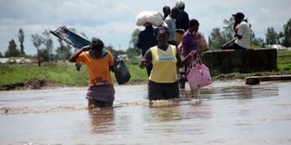
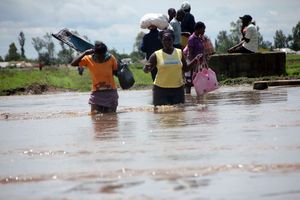
Passengers walk through the flooded Tana Delta region.
Photo credit: Kevin Odit| NMG
But, as with many scientific phenomena, this relationship is neither automatic nor does it materialise uniformly. Further, rainfall in the region often depends on other factors such as conditions in the Indian Ocean, regional wind patterns and the movement of what is known as the Intertropical Convergence Zone, among other influences.
Indeed, Kenya’s weatherman has attributed the delayed onset in some areas to low-pressure systems over the northern Indian Ocean that temporarily disrupted the southward movement of the rain-bearing convergence zone.
This is a useful reminder that the atmosphere does not respond to a single climate signal in isolation.
There is also the question of what was actually forecast. In reality, a seasonal outlook indicating a high probability of above-normal rainfall does not always mean that heavy rain will fall everywhere, or that it must begin on a particular date.
It simply means the accumulated rainfall over the season is more likely to exceed the historical average. A late start, therefore, can still be followed by intense rainfall sufficient to make the entire season wetter than normal. But similarly, the anticipated rainfall may never materialise at all.
In any case, the October–December season is not yet over and, therefore, it would be premature to pronounce the regional forecast a total failure.
But that does not mean that the weatherman can simply shrug off the public concerns and turn to the next forecast. From a science communication perspective, the more consequential question is glaring: if uncertainty was always part of the forecast, how is it that so many people ended up expecting an immediate and almost guaranteed heavy downpour throughout the region?
In other words, what was lost in translation between the time the forecast was made and the time the public got the message? The reality is that too often, too much attention is devoted to announcing what the weather might do, and too little goes into explaining what that information actually means for the decisions people must make.
Transporters wade through along Katani Syokimau road which has been impassable for days since Elnino.
Photo credit: File | Nation Media Group
Consider the case of three farmers spread across the region: one in eastern Kenya, one in northern Tanzania, and another in western Uganda.
They may all hear that the region faces enhanced rainfall, but their planting decisions will require more specific local information, such as when the rains are likely to begin in their specific region, whether the onset will be sustained, and if there is a risk of a prolonged dry spell after the first showers. Yet an East Africa-wide forecast, however scientifically sound, cannot substitute for such localised information.
But as the region mulls over what went wrong, there is an even greater danger going forward.
When forecasts appear repeatedly to promise more than the weather delivers, citizens may begin ignoring subsequent warnings. This would have devastating consequences, especially in areas where floods and landslides already claim lives and destroy livelihoods.
This means that the problem may not necessarily be about the accuracy of forecasts, important as that is.
Transparent communication
Meteorological institutions must also focus on more transparent communication of uncertainty in their forecasts and give regular updates when conditions change.
They should explain to the public what has changed, whether the underlying assumptions still hold and what the revisions mean for farmers, schools, businesses and disaster managers.
This is because the true credibility of any early-warning system ultimately rests on whether the information it contains enables people to make better decisions to avoid or minimise loss.
Dr Ageyo is the Editor-in-Chief of Nation Media Group – Uganda. He holds a PhD in media studies with research interests in science, environment and climate change communication.